IMAGES TAKEN NEAR TO
Merlin Court, CARLISLE, CA2 7NY
Introduction
This page details the photographs taken nearby to Merlin Court, CA2 7NY by members of the Geograph project.
The Geograph project started in 2005 with the aim of publishing, organising and preserving representative images for every square kilometre of Great Britain, Ireland and the Isle of Man.

There are currently over 7.5m images from over14,400 individuals and you can help contribute to the project by visiting https://www.geograph.org.uk
Image Map
Images are licensed for reuse under creativecommons.org/licenses/by-sa/2.0
Notes
- Clicking on the map will re-center to the selected point.
- The higher the marker number, the further away the image location is from the centre of the postcode.
Image Listing (68 Images Found)
Images are licensed for reuse under creativecommons.org/licenses/by-sa/2.0
Image
Details
Distance
1
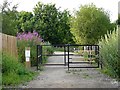
Entrance to Engine Lonning - recreation and wildlife area
Not a conventional park, Engine Lonning is a former rail yard that has been allowed to return to nature. It is managed by Carlisle City Council http://www.carlisle.gov.uk/leisure_and_culture/parks_and_open_spaces/parks_and_open_spaces/engine_lonning.aspx .
Image: © Rose and Trev Clough
Taken: 5 Jul 2009
0.03 miles
2

Cumberland Infirmary, Carlisle
The flagship of the national PFI programme was officially opened by the Rt. Hon. Tony Blair, Prime Minister, in June 2000.
http://www.visitcumbria.com/hospitals.htm
Image: © Simon Ledingham
Taken: 15 Dec 2004
0.05 miles
3
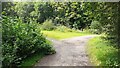
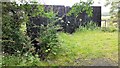
Junction of footpaths at north end of Engine Lonning
Image: © Roger Templeman
Taken: 12 Jul 2021
0.05 miles
4
Footpath at south end of Engine Lonning
Image: © Roger Templeman
Taken: 12 Jul 2021
0.07 miles
5
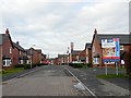
Turnstone Park
A recent housing development. It is built on the former Creighton Rugby Club ground, which was called Carr's Field.
Image: © Rose and Trev Clough
Taken: 27 Feb 2009
0.09 miles
6
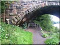
Under the arches of the Engine Lonning Bridge
The path under the arch of the old railway bridge which used to carry the "Waverley" railway line (Carlisle to Edinburgh) carries both Hadrians Wall National Trail http://www.nationaltrail.co.uk/hadrianswall/ and Hadrian's Cycleway http://www.cycle-routes.org/hadrianscycleway/ . For cyclists, it is a fairly unsatisfactory route (described as "interim") as it requires cyclists to negotiate a flight of steps with a "wheeling ramp" immediately beyond the bridge - not easy with a fully-laden bike.
Image: © Oliver Dixon
Taken: 28 Aug 2008
0.12 miles
7
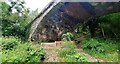
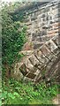
Blocked SE end of Viaduct Bridge
Ordnance Survey records indicate that a benchmark levelled at 19.455m above Newlyn Datum was verified in 1954 on top of the SW bridge parapet (near the left hand side of the image)
Image: © Roger Templeman
Taken: 12 Jul 2021
0.12 miles
8
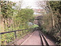
The steps down to go under a disused railway bridge
Image: © Ian S
Taken: 2 Apr 2012
0.13 miles
9
Footpath on SE bank of River Eden passing under SE arch of Viaduct Bridge
Image: © Roger Templeman
Taken: 12 Jul 2021
0.13 miles
10
SE end of Viaduct Bridge viewed from River Eden footpath
There is an Ordnance Survey benchmark Image on the abutment wall left of the base of the arch where ivy has been removed
Image: © Roger Templeman
Taken: 12 Jul 2021
0.13 miles