IMAGES TAKEN NEAR TO
Sheehan Gardens, CARLISLE, CA2 7GY
Introduction
This page details the photographs taken nearby to Sheehan Gardens, CA2 7GY by members of the Geograph project.
The Geograph project started in 2005 with the aim of publishing, organising and preserving representative images for every square kilometre of Great Britain, Ireland and the Isle of Man.

There are currently over 7.5m images from over14,400 individuals and you can help contribute to the project by visiting https://www.geograph.org.uk
Image Map (Loading...)


Getting Data...Please wait
Leaflet Map data © OpenStreetMap
Images are licensed for reuse under creativecommons.org/licenses/by-sa/2.0
Notes
- Clicking on the map will re-center to the selected point.
- The higher the marker number, the further away the image location is from the centre of the postcode.
Image Listing (27 Images Found)
Images are licensed for reuse under creativecommons.org/licenses/by-sa/2.0
Image
Details
Distance
2
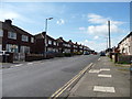
#152 Orton Road - pebbledashed and for sale
Ordnance Survey records indicate that in 1971 there was a benchmark on the left hand side of the house at its front corner. The mark now hidden by the pebbledash. See www.bench-marks.org.uk/bm114397
Image: © Luke Shaw
Taken: 3 Dec 2019
0.10 miles
3
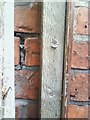
Benchmark on #172 Orton Road
Ordnance Survey cut mark benchmark described on the Bench Mark Database at www.bench-marks.org.uk/bm113297
Image: © Luke Shaw
Taken: 3 Dec 2019
0.10 miles
4
Nos.182-172 (evens) Orton Road
There is an OS benchmark Image on the side of the nearest house at its front corner
Image: © Luke Shaw
Taken: 3 Dec 2019
0.11 miles
5
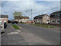
West-bound bus stop, Orton Road, Carlisle
On at least two routes.
Image: © Christine Johnstone
Taken: 11 Apr 2014
0.13 miles
6
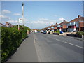
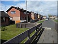
Houses on the corner, Skelwith Close, Carlisle
This estate was built no later than the early 1970s, as it is on my 1974 OS map.
Image: © Christine Johnstone
Taken: 11 Apr 2014
0.16 miles
7
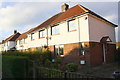
South end, Skelwith Close, Carlisle
Seen from the footpath from Orton Road.
Image: © Christine Johnstone
Taken: 11 Apr 2014
0.17 miles
8
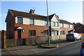
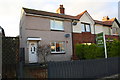
Nos. 16-10 (evens) Shady Grove Road
There is an OS benchmark Image on the side of the left hand house near its front corner
Image: © Luke Shaw
Taken: 3 Jan 2020
0.17 miles
9
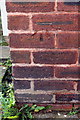
Benchmark hiding behind gatepost at #16 Shadygrove Road
Ordnance Survey cut mark benchmark which is described on the Bench Mark Database at http://www.bench-marks.org.uk/bm34902.
Image: © Roger Templeman
Taken: 17 Jul 2010
0.17 miles
10
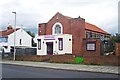
Community Reach, Shady Grove Road
This building used to be called Raffles Community Church (as seen on Google Street View, 2012 https://goo.gl/maps/LGeNfrnLpBp ). Now run by the charity Community Reach http://www.communityreach.org , who have opened the Noah's Ark soft play centre here.
Marked on 1967 OS map as Salvation Army Hall.
Image: © Rose and Trev Clough
Taken: 2 Sep 2015
0.18 miles