IMAGES TAKEN NEAR TO
Bishops Close, CARLISLE, CA2 7BH
Introduction
This page details the photographs taken nearby to Bishops Close, CA2 7BH by members of the Geograph project.
The Geograph project started in 2005 with the aim of publishing, organising and preserving representative images for every square kilometre of Great Britain, Ireland and the Isle of Man.

There are currently over 7.5m images from over14,400 individuals and you can help contribute to the project by visiting https://www.geograph.org.uk
Image Map
Images are licensed for reuse under creativecommons.org/licenses/by-sa/2.0
Notes
- Clicking on the map will re-center to the selected point.
- The higher the marker number, the further away the image location is from the centre of the postcode.
Image Listing (101 Images Found)
Images are licensed for reuse under creativecommons.org/licenses/by-sa/2.0
Image
Details
Distance
1
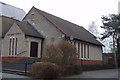
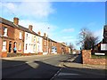
Holy Trinity Church, Carlisle
New church built 1980/1 to replace decaying sandstone building nearby.
Image: © Tom Howe
Taken: 7 Feb 2010
0.02 miles
2
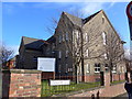
Holy Trinity Church, Carlisle: mid-February 2015
Image: © Basher Eyre
Taken: 17 Feb 2015
0.02 miles
3
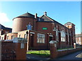
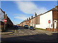
Wigton Road Methodist Church, Carlisle: mid-February 2015
Image: © Basher Eyre
Taken: 17 Feb 2015
0.04 miles
4
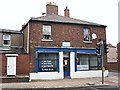
The last laundrette in town?
Poly Clean, Wigton Road.
In September 2013, this was the only laundrette I could find in Carlisle. In the early 2000s there were at least two more, in Furze Street (now Bargain Booze) and Beaconsfield Street (demolished).
Image: © Rose and Trev Clough
Taken: 24 Sep 2013
0.04 miles
7
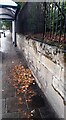
Wall and bus shelter on NW side of Wigton Road opposite Silloth Street
There is what appears to be an Ordnance Survey benchmark Image on the wall's third stone above the pavement near the right edge of the image
Image: © Roger Templeman
Taken: 2 Oct 2021
0.07 miles
8
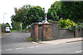
Closed toilet and former railway line, Wigton Road
The gents toilet was demolished in 2013 (closer view here Image ).
The lane on the left, behind Silloth Street, follows the line of a former railway which closed in 1969. This was originally the Canal Branch of the Newcastle and Carlisle Railway (opened 1837, from London Road Station to Carlisle Canal Basin).
Image: © Rose and Trev Clough
Taken: 8 Sep 2011
0.07 miles
9

Disused public convenience, Wigton Road
Gents toilet, demolished in 2013.
For view of location, see Image .
Image: © Rose and Trev Clough
Taken: 9 Oct 2011
0.07 miles
10

Abutment of dismantled railway bridge
At the junction of Canal Street (left) and Wigton Road. The line here opened in 1837, as a goods extension from the Newcastle and Carlisle Railway's London Road depot to the Carlisle Canal basin. The bridge was rebuilt at least twice, following a collapse in 1875 and for road widening in the 1920s (see Cumberland News article 27.03.2009 http://www.cumberlandnews.co.uk/features/christmas/The-night-a-goods-train-took-the-plunge-0c1a8180-67ae-474c-b75c-f036b20090da-ds ). It ceased to be used after the Waverley Line closed in 1969, and was demolished in 1974.
See also Image .
Image: © Rose and Trev Clough
Taken: 24 Sep 2013
0.07 miles