IMAGES TAKEN NEAR TO
Leatham Street, CARLISLE, CA2 7BG
Introduction
This page details the photographs taken nearby to Leatham Street, CA2 7BG by members of the Geograph project.
The Geograph project started in 2005 with the aim of publishing, organising and preserving representative images for every square kilometre of Great Britain, Ireland and the Isle of Man.

There are currently over 7.5m images from over14,400 individuals and you can help contribute to the project by visiting https://www.geograph.org.uk
Image Map
Images are licensed for reuse under creativecommons.org/licenses/by-sa/2.0
Notes
- Clicking on the map will re-center to the selected point.
- The higher the marker number, the further away the image location is from the centre of the postcode.
Image Listing (91 Images Found)
Images are licensed for reuse under creativecommons.org/licenses/by-sa/2.0
Image
Details
Distance
1
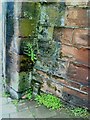
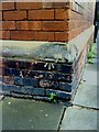
Benchmark on dismantled railway bridge
Ordnance Survey cut mark benchmark at bottom of remains of railway bridge on south side of Port Road. More information about the mark may be found on the Bench Mark Database at http://www.bench-marks.org.uk/bm30960.
Image: © Roger Templeman
Taken: 17 Jul 2010
0.03 miles
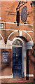
2
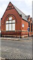
Caldew Lea Primary School at Ashley Street / Head Street junction
There is an Ordnance Survey benchmark Image on the near corner, left hand face, of the school
Image: © Roger Templeman
Taken: 12 Jul 2021
0.05 miles
3
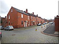
Carlisle - Head Street
Old red brick terrace houses viewed from Canal Street.
Image: © James Emmans
Taken: 12 Sep 2016
0.05 miles
4
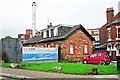
Former gatehouse to Carlisle Canal Basin
The Carlisle Canal ran from here to Port Carlisle http://www.geograph.org.uk/photo/933220 . It was only open for 30 years (1823-1853), then it was filled in to become a railway line. For history, see http://www.canalroutes.net/Carlisle-Canal.html .
Some of the original buildings at the canal basin, including the bonded warehouse and customs house, survived until the mid 1970s-early 1980s. The Port Road Business Park was created on the site, and now only the gatehouse remains.
McVitie's (formerly Carr's) biscuit factory is behind the house, with the Jovial Sailor pub on the right.
Image: © Rose and Trev Clough
Taken: 9 Oct 2011
0.05 miles
5
Benchmark on School
Ordnance Survey cut mark benchmark on school. The mark is described on the Bench Mark Database at http://www.bench-marks.org.uk/bm30957.
Image: © Roger Templeman
Taken: 17 Jul 2010
0.05 miles
6
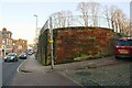
Abutment of bridge of dismantled railway at east end of Port Road
There is an Ordnance Survey benchmark Image on the abutment left of the post of the parking restriction sign
Image: © Roger Templeman
Taken: 29 Nov 2019
0.06 miles
7
Jovial Sailor, Caldcotes, Carlisle - November 2016 (3)
Faded pub sign and entrance to the lounge bar - the glass over the door depicts a dancing sailor, although it is probably best viewed from inside.
See also: Image] .
Image: © The Carlisle Kid
Taken: 26 Nov 2016
0.06 miles
8

Jovial Sailor, Caldcotes, Carlisle - November 2016 (2)
Faded pub sign and entrance to the public bar. The glass over the door depicts a dancing sailor - although it is probably best viewed from inside.
See also: Image] .
Image: © The Carlisle Kid
Taken: 26 Nov 2016
0.06 miles
9
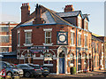
Jovial Sailor, Caldcotes, Carlisle - November 2016 (1)
Dating from at least 1837, the original Jovial Sailor's Inn was sited further down Caldcotes to the right of the present building. Demolished in 1903, the current Jovial Sailor opened in March 1904. It came under State management in August 1916 and returned to private ownership on 7 May 1973 when sold to the John Smith Brewing Group. Still trading.
See also: Image] and Image] .
Image: © The Carlisle Kid
Taken: 26 Nov 2016
0.06 miles
10
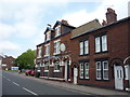
The Jovial Sailor, Carlisle
On Caldcoates.
Image: © JThomas
Taken: 28 May 2016
0.06 miles