IMAGES TAKEN NEAR TO
Canal Court, Infirmary Street, CARLISLE, CA2 7AG
Introduction
This page details the photographs taken nearby to Canal Court, Infirmary Street, CA2 7AG by members of the Geograph project.
The Geograph project started in 2005 with the aim of publishing, organising and preserving representative images for every square kilometre of Great Britain, Ireland and the Isle of Man.

There are currently over 7.5m images from over14,400 individuals and you can help contribute to the project by visiting https://www.geograph.org.uk
Image Map
Images are licensed for reuse under creativecommons.org/licenses/by-sa/2.0
Notes
- Clicking on the map will re-center to the selected point.
- The higher the marker number, the further away the image location is from the centre of the postcode.
Image Listing (91 Images Found)
Images are licensed for reuse under creativecommons.org/licenses/by-sa/2.0
Image
Details
Distance
1
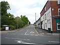
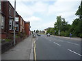
Infirmary Street, Carlisle
Looking north from the B5307.
Image: © JThomas
Taken: 28 May 2016
0.06 miles
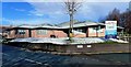
2
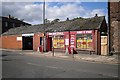
Newtown Garage and Port Road Stores
Image: © Rose and Trev Clough
Taken: 8 Sep 2011
0.06 miles
3
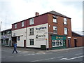
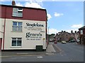
Genco's Sandwich Bar, Carlisle
On Newtown Road.
Image: © JThomas
Taken: 28 May 2016
0.07 miles
5
Bus stop on the B5307, Carlisle
Looking west.
Image: © JThomas
Taken: 28 May 2016
0.08 miles
6
Eden Medical Group
A modern Health Centre in Carlisle's Willow Holme area.
Image: © Mary and Angus Hogg
Taken: 31 Jan 2015
0.08 miles
7
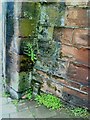
Benchmark on dismantled railway bridge
Ordnance Survey cut mark benchmark at bottom of remains of railway bridge on south side of Port Road. More information about the mark may be found on the Bench Mark Database at http://www.bench-marks.org.uk/bm30960.
Image: © Roger Templeman
Taken: 17 Jul 2010
0.10 miles
8
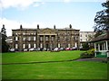
The original Cumberland Infirmary
Built between 1830-32, financed by subscriptions from wealthy benefactors, enabling charity patients to receive treatment. Extensions and other buildings were added to the hospital over the years - for historical information, see Carlisle Encyclopedia http://www.carlisleshistory.co.uk/page25.htm .
A new Cumberland Infirmary, built nearby on the same site, opened in 2000 - see Image .
This old building is still in hospital use.
Image: © Rose and Trev Clough
Taken: 8 Sep 2011
0.10 miles
9
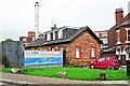
Former gatehouse to Carlisle Canal Basin
The Carlisle Canal ran from here to Port Carlisle http://www.geograph.org.uk/photo/933220 . It was only open for 30 years (1823-1853), then it was filled in to become a railway line. For history, see http://www.canalroutes.net/Carlisle-Canal.html .
Some of the original buildings at the canal basin, including the bonded warehouse and customs house, survived until the mid 1970s-early 1980s. The Port Road Business Park was created on the site, and now only the gatehouse remains.
McVitie's (formerly Carr's) biscuit factory is behind the house, with the Jovial Sailor pub on the right.
Image: © Rose and Trev Clough
Taken: 9 Oct 2011
0.10 miles
10
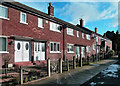
Granville Road
An attractive red brick row in central Carlisle.
Image: © Mary and Angus Hogg
Taken: 31 Jan 2015
0.11 miles