IMAGES TAKEN NEAR TO
Port Road Business Park, CARLISLE, CA2 7AF
Introduction
This page details the photographs taken nearby to Port Road Business Park, CA2 7AF by members of the Geograph project.
The Geograph project started in 2005 with the aim of publishing, organising and preserving representative images for every square kilometre of Great Britain, Ireland and the Isle of Man.

There are currently over 7.5m images from over14,400 individuals and you can help contribute to the project by visiting https://www.geograph.org.uk
Image Map
Images are licensed for reuse under creativecommons.org/licenses/by-sa/2.0
Notes
- Clicking on the map will re-center to the selected point.
- The higher the marker number, the further away the image location is from the centre of the postcode.
Image Listing (40 Images Found)
Images are licensed for reuse under creativecommons.org/licenses/by-sa/2.0
Image
Details
Distance
1
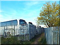
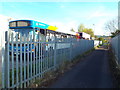
Footpath through Willowholme Industrial Estate, Carlisle
A footpath through the Willowholme Industrial Estate in Carlisle. Here the path runs past the back of a coach depot.
Image: © Malc McDonald
Taken: 23 Apr 2015
0.09 miles
2
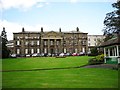
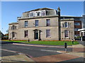
The original Cumberland Infirmary
Built between 1830-32, financed by subscriptions from wealthy benefactors, enabling charity patients to receive treatment. Extensions and other buildings were added to the hospital over the years - for historical information, see Carlisle Encyclopedia http://www.carlisleshistory.co.uk/page25.htm .
A new Cumberland Infirmary, built nearby on the same site, opened in 2000 - see Image .
This old building is still in hospital use.
Image: © Rose and Trev Clough
Taken: 8 Sep 2011
0.11 miles
3
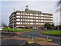
Redundant building at the Cumberland Infirmary
This block was built in the 1970s as an extension to the old Cumberland Infirmary http://www.geograph.org.uk/photo/2646570 . When the new infirmary http://www.geograph.org.uk/photo/74610 opened in 2000, nearly all functions were shifted across from here. Apart from a few services on the ground floor, the building appears to have been unused ever since.
Information update : the building was demolished in 2018-2019.
Image: © Rose and Trev Clough
Taken: 16 Feb 2015
0.13 miles
4
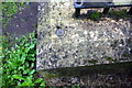
Environment Agency benchmark on wall of steps from road to riverside path
Image: © Roger Templeman
Taken: 16 Aug 2019
0.14 miles
5
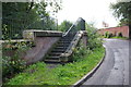
Steps from industrial road to path along Parham Beck
There is an Environment Agency benchmark Image on top of the near end of the wall on the right hand side of the steps
Image: © Roger Templeman
Taken: 16 Aug 2019
0.15 miles
6

The Cumberland Infirmary, Carlisle
Beside the pedestrian access to the hospital from Clift Street.
Image: © David Rogers
Taken: 8 Oct 2009
0.17 miles
7
Public footpath, Willowholme Industrial Estate, Carlisle
A public footpath through the Willowholme Industrial Estate in Carlisle. Here the path passes the Stagecoach bus depot. Stagecoach operate most of the bus services in and around Carlisle.
Look closely at the second bus in the line. It is a double-decker which lost its roof when it collided with a railway bridge.
Image: © Malc McDonald
Taken: 23 Apr 2015
0.17 miles
8
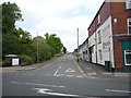
Infirmary Street, Carlisle
Looking north from the B5307.
Image: © JThomas
Taken: 28 May 2016
0.17 miles
9

Eden Medical Group
A modern Health Centre in Carlisle's Willow Holme area.
Image: © Mary and Angus Hogg
Taken: 31 Jan 2015
0.18 miles
10
The Cumberland Infirmary, Carlisle
The Old Doctors House still stands beside the new Infirmary buildings.
Image: © David Rogers
Taken: 8 Oct 2009
0.18 miles