IMAGES TAKEN NEAR TO
Westrigg Road, CARLISLE, CA2 6LE
Introduction
This page details the photographs taken nearby to Westrigg Road, CA2 6LE by members of the Geograph project.
The Geograph project started in 2005 with the aim of publishing, organising and preserving representative images for every square kilometre of Great Britain, Ireland and the Isle of Man.

There are currently over 7.5m images from over14,400 individuals and you can help contribute to the project by visiting https://www.geograph.org.uk
Image Map
Images are licensed for reuse under creativecommons.org/licenses/by-sa/2.0
Notes
- Clicking on the map will re-center to the selected point.
- The higher the marker number, the further away the image location is from the centre of the postcode.
Image Listing (19 Images Found)
Images are licensed for reuse under creativecommons.org/licenses/by-sa/2.0
Image
Details
Distance
1
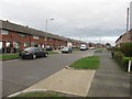
Westrigg Road, Carlisle
A quiet residential street lined with terraced houses in the Morton part of Carlisle.
Image: © Graham Robson
Taken: 30 Oct 2014
0.03 miles
2
Westrigg Road, Morton
View from Wigton Road.
Image: © Rose and Trev Clough
Taken: 14 Jun 2011
0.09 miles
3
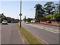
Wigton Road, Carlisle
The main A595 Wigton Road is flanked by service roads on either side which give access to the houses flanking the road.
Image: © Oliver Dixon
Taken: 18 Jul 2006
0.11 miles
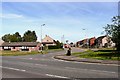
4

Entrance to Morton Leisure Centre from Wigton Road
Image: © Roger Templeman
Taken: 7 Jul 2015
0.12 miles
5

Richard Rose Academy, Morton, Carlisle
The modern building of the Richard Rose Academy, Morton. The modern building is built on the same site as a previous building which housed the school.
Image: © Graham Robson
Taken: 30 Oct 2014
0.12 miles
6
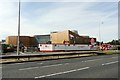
The Richard Rose Morton Academy
Nearing completion, the Academy's £26 million new building due to open in September 2011.
Morton Secondary School opened on this site in 1968. It changed to an academy http://en.wikipedia.org/wiki/Academy_%28English_school%29 in 2008.
The Morton Academy is one of a pair in Carlisle - it and the Central Academy are managed by the Richard Rose Federation http://www.richardroseacademies.org/ .
Image: © Rose and Trev Clough
Taken: 14 Jun 2011
0.13 miles
7
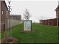
Young trees, Westrigg Road, Carlisle
A gap between houses on Westrigg Road is the location for a handful of trees which, according to the large poster, have been planted as part of the government led "The Big Tree Plant scheme". The scheme aimed to encourage communities throughout England to plant one million new trees around urban areas and communities and was scheduled to run from 2010 to 2015.
Image: © Graham Robson
Taken: 30 Oct 2014
0.13 miles
8
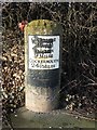
Old Milestone by the A595, south west of Carlisle
Metal plate attached to stone post by the A595, in parish of CARLISLE (CARLISLE District), Wigton Road, Morton School, 100m North of junction with Glaramara Drive, near Shuttle House, in hedge behind wide footpath/cycleway; just South of bus-shelter, on North side of road. Carlisle red stone and curved plate, erected by the Cockermouth & Carlisle turnpike trust in the 19th century.
Inscription reads:-
CARLISLE
2 MILES
WIGTON
9 MILES
COCKERMOUTH
24½ MILES
Grade II Listed. List Entry Number: 1197153
https://historicengland.org.uk/listing/the-list/list-entry/1197153
Milestone Society National ID: CU_CLCM02.
Image: © CF Smith
Taken: 6 Jan 2006
0.16 miles
9
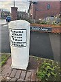
Old Milestone, A595, Carlisle
Modern resiting of milestone at new development in Suttle Lane. Metal plate attached to stone post by the A595, in parish of CARLISLE (CARLISLE District), Wigton Road, Morton School, 100m North of junction with Glaramara Drive, near Suttle House, in hedge behind wide footpath/cycleway; just South of bus-shelter, on North side of road. Carlisle red stone and curved plate, erected by the Cockermouth & Carlisle turnpike trust in the 19th century.
Image from 2006 is Image
Inscription reads: CARLISLE / 2 MILES / WIGTON / 9 MILES / COCKERMOUTH
/ 4½ MILES
Grade II Listed. List Entry Number: 1197153 https://historicengland.org.uk/listing/the-list/list-entry/1197153
Milestone Society National ID: CU_CLCM02
Image: © Karen Kelso
Taken: 29 Jan 2023
0.16 miles
10
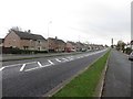
Wigton Road, Carlisle
The road is the main arterial route leading into Carlisle city centre from the south west. The houses on either side of the road are accessed by smaller lanes separated from the main carriageway by narrow grassed verges.
Image: © Graham Robson
Taken: 30 Oct 2014
0.17 miles