IMAGES TAKEN NEAR TO
Wansfell Avenue, CARLISLE, CA2 6HD
Introduction
This page details the photographs taken nearby to Wansfell Avenue, CA2 6HD by members of the Geograph project.
The Geograph project started in 2005 with the aim of publishing, organising and preserving representative images for every square kilometre of Great Britain, Ireland and the Isle of Man.

There are currently over 7.5m images from over14,400 individuals and you can help contribute to the project by visiting https://www.geograph.org.uk
Image Map
Images are licensed for reuse under creativecommons.org/licenses/by-sa/2.0
Notes
- Clicking on the map will re-center to the selected point.
- The higher the marker number, the further away the image location is from the centre of the postcode.
Image Listing (47 Images Found)
Images are licensed for reuse under creativecommons.org/licenses/by-sa/2.0
Image
Details
Distance
1
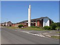
Church of Jesus Christ of Latter Day Saints, Carlisle
Striking modern church on Langrigg Road
Image: © Oliver Dixon
Taken: 18 Jul 2006
0.09 miles
2
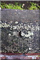
Remains of benchmark on cemetery wall
The coping stone of the wall has evidently been 'repaired' leaving only the bottom of the centre arrow cut of what was an Ordnance Survey rivet benchmark which is described on the Bench Mark Database at http://www.bench-marks.org.uk/bm39071
Image: © Roger Templeman
Taken: 7 Aug 2011
0.11 miles
3
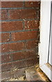
Benchmark inside garage extension of #21 Dunmail Drive
Ordnance Survey cut mark benchmark described on the Bench Mark Database at http://www.bench-marks.org.uk/bm68953
Image: © Roger Templeman
Taken: 7 Jul 2015
0.12 miles
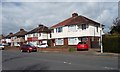
4
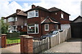
Houses on Dunmail Drive
There is an OS benchmark Image inside the garage with white door of the house in the middle of the image
Image: © Roger Templeman
Taken: 7 Jul 2015
0.12 miles
5
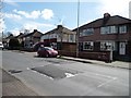
Sleeping policemen, Dunmail Drive, Carlisle
Traffic calming speed bumps in a 20mph area.
Image: © Christine Johnstone
Taken: 11 Apr 2014
0.12 miles
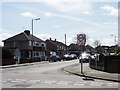
6
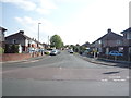
Langrigg Road
Looking south west from Dunmail Drive.
Image: © JThomas
Taken: 28 May 2016
0.12 miles
7
North end, Langrigg Road, Carlisle
Seen from Dunmail Drive.
Image: © Christine Johnstone
Taken: 11 Apr 2014
0.12 miles
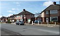
8
Houses, north side, Dunmail Drive
This suburb, west of Dalston Road [B5299], was developed no earlier than the 1930s.
Image: © Christine Johnstone
Taken: 11 Apr 2014
0.13 miles
9

Corner of Carlisle Cemetery on a wet day
The view is of the NW corner of the cemetery at the junction of Richardson Street and Dalston Road. On top of the wall to the right of street name sign used to be an OS benchmark Image levelled at 35.2635m above Ordnance Datum Newlyn in 1972.
Image: © Roger Templeman
Taken: 7 Aug 2011
0.13 miles
10
You can speed up in Langrigg Road, Carlisle
20mph zone ends as you turn south of Dunmail Drive.
Image: © Christine Johnstone
Taken: 11 Apr 2014
0.13 miles