IMAGES TAKEN NEAR TO
Dalston Road, CARLISLE, CA2 6DZ
Introduction
This page details the photographs taken nearby to Dalston Road, CA2 6DZ by members of the Geograph project.
The Geograph project started in 2005 with the aim of publishing, organising and preserving representative images for every square kilometre of Great Britain, Ireland and the Isle of Man.

There are currently over 7.5m images from over14,400 individuals and you can help contribute to the project by visiting https://www.geograph.org.uk
Image Map
Images are licensed for reuse under creativecommons.org/licenses/by-sa/2.0
Notes
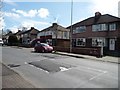
- Clicking on the map will re-center to the selected point.
- The higher the marker number, the further away the image location is from the centre of the postcode.
Image Listing (55 Images Found)
Images are licensed for reuse under creativecommons.org/licenses/by-sa/2.0
Image
Details
Distance
1
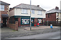
Jaspers Convenience Store
A general store and off-licence in Waldegrave Road, Longsowerby.
Image: © Rose and Trev Clough
Taken: 30 Mar 2016
0.09 miles
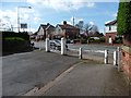
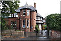
2
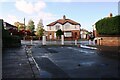
Gateway at west end of Norfolk Road at Dalston Road junction
There is an Ordnance Survey benchmark on the gatepost at the left hand side of the metal gate
Image: © Roger Templeman
Taken: 23 Oct 2020
0.09 miles
4
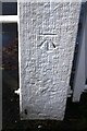
Benchmark on gatepost at west end of Norfolk Road
Ordnance Survey cut mark benchmark shown on the 1901 1:2500 Map as levelled at 87.1 feet above Liverpool Datum
Image: © Roger Templeman
Taken: 23 Oct 2020
0.09 miles
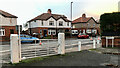
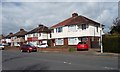
5
Western end of Norfolk Road, Carlisle
Gated to prevent vehicle access to and from the B5299.
Image: © Christine Johnstone
Taken: 11 Apr 2014
0.09 miles
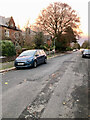
6
Houses, north side, Dunmail Drive
This suburb, west of Dalston Road [B5299], was developed no earlier than the 1930s.
Image: © Christine Johnstone
Taken: 11 Apr 2014
0.11 miles
8
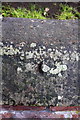
Remains of benchmark on cemetery wall
The coping stone of the wall has evidently been 'repaired' leaving only the bottom of the centre arrow cut of what was an Ordnance Survey rivet benchmark which is described on the Bench Mark Database at http://www.bench-marks.org.uk/bm39071
Image: © Roger Templeman
Taken: 7 Aug 2011
0.12 miles
9
Sleeping policemen, Dunmail Drive, Carlisle
Traffic calming speed bumps in a 20mph area.
Image: © Christine Johnstone
Taken: 11 Apr 2014
0.12 miles
10
Parkfield Nursery School, Dalston Road
There is an OS benchmark Image on the gatepost.
Image: © Roger Templeman
Taken: 7 Aug 2011
0.13 miles