IMAGES TAKEN NEAR TO
Silloth Street, CARLISLE, CA2 5WG
Introduction
This page details the photographs taken nearby to Silloth Street, CA2 5WG by members of the Geograph project.
The Geograph project started in 2005 with the aim of publishing, organising and preserving representative images for every square kilometre of Great Britain, Ireland and the Isle of Man.

There are currently over 7.5m images from over14,400 individuals and you can help contribute to the project by visiting https://www.geograph.org.uk
Image Map (127 Images)


Getting Data...Please wait
Leaflet Map data © OpenStreetMap
Images are licensed for reuse under creativecommons.org/licenses/by-sa/2.0
Notes
- Clicking on the map will re-center to the selected point.
- The higher the marker number, the further away the image location is from the centre of the postcode.
Image Listing (127 Images Found)
Images are licensed for reuse under creativecommons.org/licenses/by-sa/2.0
Image
Details
Distance
1
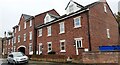
St Bedes Terrace on SW side of Silloth Street
Previously the site of a club on which Ordnance Survey records indicate a benchmark was levelled at 15.934m above Newlyn Datum in 1972.
Image: © Roger Templeman
Taken: 9 Oct 2021
0.00 miles
2
Closed toilet and former railway line, Wigton Road
The gents toilet was demolished in 2013 (closer view here Image ).
The lane on the left, behind Silloth Street, follows the line of a former railway which closed in 1969. This was originally the Canal Branch of the Newcastle and Carlisle Railway (opened 1837, from London Road Station to Carlisle Canal Basin).
Image: © Rose and Trev Clough
Taken: 8 Sep 2011
0.04 miles
3

Disused public convenience, Wigton Road
Gents toilet, demolished in 2013.
For view of location, see Image .
Image: © Rose and Trev Clough
Taken: 9 Oct 2011
0.04 miles
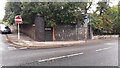
4

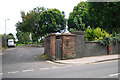
Wall and bus shelter on NW side of Wigton Road opposite Silloth Street
There is what appears to be an Ordnance Survey benchmark Image on the wall's third stone above the pavement near the right edge of the image
Image: © Roger Templeman
Taken: 2 Oct 2021
0.04 miles
5
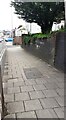
Looking NE along Wigton Road at the site of bridge of dismantled railway
There is an Ordnance Survey benchmark on the second stone above the pavement on the near corner of the bridge wall
Image: © Roger Templeman
Taken: 12 Jul 2021
0.04 miles
6
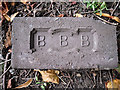
Brick from old railway bridge?
This was lying about a metre away from Image . Comparing it with other people's photos, on Flickr http://www.flickr.com/photos/nottsexminer/8175252535/ and 'Old Bricks' website http://www.penmorfa.com/bricks/england4.html , it was probably made by the Bull Bridge Brick Co in Derbyshire. We couldn't find any information about when this brickworks was operating.
Image: © Rose and Trev Clough
Taken: 24 Sep 2013
0.05 miles
7
Remains of bridge of dismantle railway at junction of Wigton Road and Canal Street
There used to be an Ordnance Survey benchmark on the left hand bridge pier Image The other side of the bridge on SE side of Wigton Road is at Image
Image: © Roger Templeman
Taken: 2 Oct 2021
0.05 miles
8

Gravestones from former Holy Trinity Church churchyard stored by boundary wall
Image: © Roger Templeman
Taken: 2 Oct 2021
0.05 miles
9
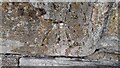
Benchmark? on wall on NW side of Wigton Road
It looks like an Ordnance Survey cut mark benchmark but there is no reference to it in OS records, nor is it shown on Old Maps
Image: © Roger Templeman
Taken: 2 Oct 2021
0.05 miles
10

Abutment of dismantled railway bridge
At the junction of Canal Street (left) and Wigton Road. The line here opened in 1837, as a goods extension from the Newcastle and Carlisle Railway's London Road depot to the Carlisle Canal basin. The bridge was rebuilt at least twice, following a collapse in 1875 and for road widening in the 1920s (see Cumberland News article 27.03.2009 http://www.cumberlandnews.co.uk/features/christmas/The-night-a-goods-train-took-the-plunge-0c1a8180-67ae-474c-b75c-f036b20090da-ds ). It ceased to be used after the Waverley Line closed in 1969, and was demolished in 1974.
See also Image .
Image: © Rose and Trev Clough
Taken: 24 Sep 2013
0.05 miles