IMAGES TAKEN NEAR TO
Queen Street, CARLISLE, CA2 5TP
Introduction
This page details the photographs taken nearby to Queen Street, CA2 5TP by members of the Geograph project.
The Geograph project started in 2005 with the aim of publishing, organising and preserving representative images for every square kilometre of Great Britain, Ireland and the Isle of Man.

There are currently over 7.5m images from over14,400 individuals and you can help contribute to the project by visiting https://www.geograph.org.uk
Image Map
Images are licensed for reuse under creativecommons.org/licenses/by-sa/2.0
Notes
- Clicking on the map will re-center to the selected point.
- The higher the marker number, the further away the image location is from the centre of the postcode.
Image Listing (222 Images Found)
Images are licensed for reuse under creativecommons.org/licenses/by-sa/2.0
Image
Details
Distance
1
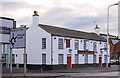
Former "Pheasant" pub - December 2016 (2)
For information on this building, see: Image] .
Image: © The Carlisle Kid
Taken: 1 Dec 2016
0.02 miles
3
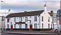
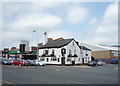
Former "Pheasant" pub - December 2016 (1)
Once three 18th century cottages combined to form a pub, the "Pheasant" opened circa 1880. Acquired by the State in August 1916, it was re-modelled internally May - October 1917 to provide meals, the Control Board being keen to provide the option of meals in comfortable surroundings. Returned to private ownership in April 1973, the pub closed in 1999 and is now a restaurant.
Photograph is for record only - I have no connection with this business and cannot advise on its products or services.
Image: © The Carlisle Kid
Taken: 1 Dec 2016
0.03 miles
4
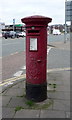
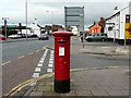
Edward VII postbox on Church Street, Carlisle
Postbox No. CA2 73.
See Image] for context.
Image: © JThomas
Taken: 28 May 2016
0.04 miles
5
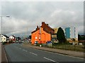
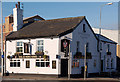
Edward VII pillar box, Church Street, Caldewgate
The white building on the right, now a Chinese restaurant, was formerly the Pheasant Inn. It is Grade II listed and dates from the late 18th century.
Image: © Rose and Trev Clough
Taken: 7 Sep 2008
0.04 miles
6
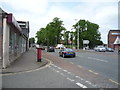
Church Street, Carlisle
Showing position of Postbox No. CA2 73.
See Image] for postbox.
Image: © JThomas
Taken: 28 May 2016
0.04 miles
7
Brightly coloured buildings, John Street
Viewed from Church Street, the Curry Master takeaway shows its orange side. The modern blue, grey and yellow block is student accommodation.
Image: © Rose and Trev Clough
Taken: 7 Sep 2008
0.05 miles
8
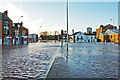
Floodwater in Caldewgate
John Street (left) merges into Church Street just past the traffic lights.
McVitie's biscuit factory is on the far right, with the Joiners Arms (white building) in front of it.
The water level had already dropped by this time, as seen by a tide mark of debris further back on the road.
Image: © Rose and Trev Clough
Taken: 6 Dec 2015
0.05 miles
10
The Joiners Arms, Caldewgate, Carlisle - November 2016 (3)
Another view of this pub taken from the junction of Church Street, Bridge Street and John Street. For information on the building, see: Image] .
Image: © The Carlisle Kid
Taken: 26 Nov 2016
0.05 miles