IMAGES TAKEN NEAR TO
Willowbank, CARLISLE, CA2 5RY
Introduction
This page details the photographs taken nearby to Willowbank, CA2 5RY by members of the Geograph project.
The Geograph project started in 2005 with the aim of publishing, organising and preserving representative images for every square kilometre of Great Britain, Ireland and the Isle of Man.

There are currently over 7.5m images from over14,400 individuals and you can help contribute to the project by visiting https://www.geograph.org.uk
Image Map
Images are licensed for reuse under creativecommons.org/licenses/by-sa/2.0
Notes
- Clicking on the map will re-center to the selected point.
- The higher the marker number, the further away the image location is from the centre of the postcode.
Image Listing (547 Images Found)
Images are licensed for reuse under creativecommons.org/licenses/by-sa/2.0
Image
Details
Distance
1
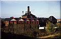
Theakston Carlisle Brewery
That's what it said on the water tank. I wonder what it is now?
Image: © Chris Allen
Taken: 3 Nov 1986
0.01 miles
2
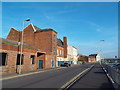
Willow Holme Road, Carlisle
Willow Holme Road in Carlisle.
Image: © Malc McDonald
Taken: 23 Apr 2015
0.02 miles
3
Carlisle Old Brewery Residences
Taken from a train heading south on the West Coast Main Line.
Image: © Richard Cooke
Taken: 17 Jul 2013
0.04 miles
4
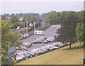
Devonshire Walk Car Park
The car park for the castle, with a freight train passing.
Image: © Stephen Craven
Taken: 16 May 2002
0.04 miles
5
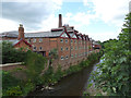
Brewery Residence and the River Caldew
The Brewery Residence is the former Carlisle Old Brewery which has been converted to student residences and a YHA hostel.
Image: © habiloid
Taken: 1 Aug 2016
0.06 miles
6
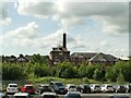
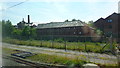
Carlisle old brewery
Viewed from Devonshire Walk across the river and railway. Built in the mid-19th century, on an older brewery site, for the Carlisle Old Brewery Company, becoming part of the Theakstons group in 1974. Part of the brewery was demolished after closure in 1987, the rest has been converted to a student residence and gym. For a fuller history see the grade II listing (list entry 1208869).
Image: © Stephen Craven
Taken: 23 Aug 2021
0.06 miles
7
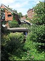
Stream west of River Caldew
The Little Caldew or Millrace originated as an artificial water course from the River Caldew, designed to supply water to businesses such as Carlisle's former Cotton Mill.
Image: © Andrew Curtis
Taken: 27 Jul 2018
0.06 miles
8
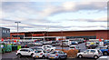
Site of "Graham's Queens Brewery" - December 2016
Opened in 1860 and also sometimes known as Queen's Brewery (Graham's), the brewery was fronted by the Queens Head Inn and the Royal Oak Inn (approximately where I am standing). The brewery came under State control in September 1916 and was almost immediately closed, the buildings being demolished in 1928/29. The Queens Head was closed in 1918, while the Royal Oak became an off-licence by 1920 and was demolished in 1987. It is not clear what use was made of the brewery site in the years between 1929 and the construction of Sainsbury's circa 2005.
Sainsbury's wine and spirit shelves are situated on the approximate site of the "William James MP" pub, which closed in 1912!
Alex advises "Usage in the 1960's and 1970's the site was the location of Fred Proudfoots banana ripening rooms, potato bagging and also his HGV repair workshops".
Photograph is for record only - I have no connection with this business and cannot advise on its products or services.
Image: © The Carlisle Kid
Taken: 1 Dec 2016
0.06 miles
9
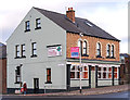
Former "Globe" pub - December 2016 (1)
The Globe - also known as the Globe Inn - came under State management in August 1916 and returned to private ownership in April 1973. The pub closed on 8 December 2010 and was converted to a retail outlet with student accommodation above. Sadly, the retailer closed following "Storm Desmond" in December 2015 and the future of the ground floor is uncertain.
For a view of the pub when open, see: Image] .
Image: © The Carlisle Kid
Taken: 1 Dec 2016
0.06 miles
10
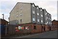
Former GPO building, Willow Holme Road
Now apartments above car park
Image: © Roger Templeman
Taken: 16 Aug 2019
0.06 miles