IMAGES TAKEN NEAR TO
Denton Mill Close, CARLISLE, CA2 5NZ
Introduction
This page details the photographs taken nearby to Denton Mill Close, CA2 5NZ by members of the Geograph project.
The Geograph project started in 2005 with the aim of publishing, organising and preserving representative images for every square kilometre of Great Britain, Ireland and the Isle of Man.

There are currently over 7.5m images from over14,400 individuals and you can help contribute to the project by visiting https://www.geograph.org.uk
Image Map
Images are licensed for reuse under creativecommons.org/licenses/by-sa/2.0
Notes
- Clicking on the map will re-center to the selected point.
- The higher the marker number, the further away the image location is from the centre of the postcode.
Image Listing (61 Images Found)
Images are licensed for reuse under creativecommons.org/licenses/by-sa/2.0
Image
Details
Distance
2
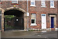
Arched gated entrance beside #19 North Street
On the white base of the archway side next to the lamp post is an OS benchmark Image
Image: © Roger Templeman
Taken: 7 Aug 2011
0.07 miles
3
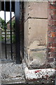
Benchmark on the archway side of #19 North Street
Ordnance Survey pivot benchmark described on the Bench Mark Database at http://www.bench-marks.org.uk/bm39015
Image: © Roger Templeman
Taken: 7 Aug 2011
0.07 miles
4
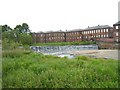
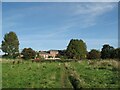
Holme Head weir
In low water for May - see Image
Image: © Tony Vickers
Taken: 25 May 2008
0.08 miles
5
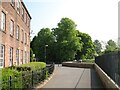
The Cumbria Way by The Mill at Holme Head
The Cumbria Way long distance path follows the Caldew Cycleway beside the Grade II Listed former Ferguson Brothers Mill at Holme Head Works (next photograph Image).
Image: © Adrian Taylor
Taken: 21 May 2018
0.09 miles
6

Holme Head Weir
The River Caldew at Denton Holme - flowing fast but not high enough for nearby floodgates to be closed.
A fish pass (top left) has been installed to aid to aid the migration of salmon returning to their spawning grounds upstream.
Image: © Rose and Trev Clough
Taken: 25 Dec 2012
0.09 miles
7
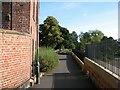
The Cumbria Way, Holme Head
The Cumbria Way follows a riverside public footpath from Cummersdale Mills, here approaching The Mill at Holme Head (next photograph Image).
Image: © Adrian Taylor
Taken: 28 Sep 2013
0.09 miles
8
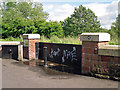
Closed flood gate, Holme Head
Part of a £38m flood defence scheme for Carlisle, completed in 2010.
There is a circular plaque attached to the gatepost on the right - for close-up, see Image .
Image: © Rose and Trev Clough
Taken: 24 Jun 2012
0.09 miles
9

Flood wall art plaque, Holme Head
In 2009 an art work of 40 enamel plaques with local and flood related themes, commissioned by the Environment Agency, was installed along Carlisle's newly built flood walls. For more information, see Image .
For location of this plaque, see Image It is on the theme of industrial heritage, representing the nearby Ferguson's textile mill. We believe the artist is Paul Taylor - please get in touch if this is incorrect.
Image: © Rose and Trev Clough
Taken: 24 Jun 2012
0.09 miles
10
The Cumbria Way, The Mill at Holme Head
The Cumbria Way long distance path follows the Caldew Cycleway between the former Ferguson Brothers Mill at Holme Head Works and the River Caldew (next photograph Image).
Image: © Adrian Taylor
Taken: 28 Sep 2013
0.09 miles