IMAGES TAKEN NEAR TO
Cumberland Street, CARLISLE, CA2 5JH
Introduction
This page details the photographs taken nearby to Cumberland Street, CA2 5JH by members of the Geograph project.
The Geograph project started in 2005 with the aim of publishing, organising and preserving representative images for every square kilometre of Great Britain, Ireland and the Isle of Man.

There are currently over 7.5m images from over14,400 individuals and you can help contribute to the project by visiting https://www.geograph.org.uk
Image Map
Images are licensed for reuse under creativecommons.org/licenses/by-sa/2.0
Notes
- Clicking on the map will re-center to the selected point.
- The higher the marker number, the further away the image location is from the centre of the postcode.
Image Listing (101 Images Found)
Images are licensed for reuse under creativecommons.org/licenses/by-sa/2.0
Image
Details
Distance
1
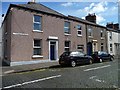
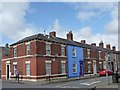
Cumberland Street, Carlisle
In street size, Cumberland is much smaller than Westmorland next door.
Image: © Christine Johnstone
Taken: 11 Apr 2014
0.01 miles
2
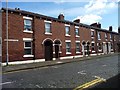
Westmorland Street, Carlisle
Looking south from Norfolk Street.
Image: © Christine Johnstone
Taken: 11 Apr 2014
0.02 miles
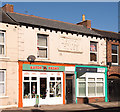
3
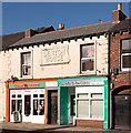
Former "Denton Inn", 110 Denton Street - March 2018 (1)
Once again, State Management records serve only to confuse. While there seems to have been an off-licence possibly called the "Denton Inn" at 50 Denton Street, the property seen here was the original site of the "Denton Inn" at 110 Denton Street. It first appears in local directories of 1880 and probably dates from this period. It was acquired by the State Management Scheme on 22 August 1916 and is recorded as closed in 1927 due to adverse police reports. What happened next is still unclear, but the Scheme sale catalogue records the "Denton Inn" as 50 Denton Street (see: Image] ), when it may have been known as "Denton Wine Stores.
Photograph is for record only - I have no connection with any business seen in this view and cannot advise on their products or services.
Image: © The Carlisle Kid
Taken: 26 Mar 2018
0.03 miles
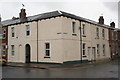
4
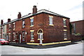
Houses on Westmorland Street at Norfolk Street junction
Image: © Roger Templeman
Taken: 7 Jul 2015
0.04 miles
5
Westmorland Street, Carlisle
Somebody likes to be noticed. Looking north from Norfolk Street.
Image: © Christine Johnstone
Taken: 11 Apr 2014
0.05 miles
6

Damaged benchmark on #1 East Dale Street
The house owners appear to trying to destroy this Ordnance Survey pivot benchmark which is described on the Bench Mark Database at http://www.bench-marks.org.uk/bm39014
Image: © Roger Templeman
Taken: 7 Aug 2011
0.05 miles
7
#1 East Dale Street at junction with Denton Street
The cement patching on the green skirt at the corner conceals an OS benchmark Image
Image: © Roger Templeman
Taken: 7 Aug 2011
0.05 miles
8
Former "Denton Inn", 110 Denton Street - March 2018 (2)
For information on this building, see: Image] .
Image: © The Carlisle Kid
Taken: 26 Mar 2018
0.06 miles
9
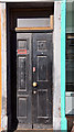
Former "Denton Inn", 110 Denton Street - March 2018 (3)
Entrance to 110 Denton Street - which has been decorated with seahorses. It is not clear if this was the former entrance to the "Denton Inn".
For information on the former "Denton Inn", see: Image] .
Image: © The Carlisle Kid
Taken: 26 Mar 2018
0.06 miles
10

Former "Denton Inn", 110 Denton Street - March 2018 (4)
Decorated glass panels which appear to be all that survives internally from the days when the premises were the "Denton Inn".
For information on the former "Denton Inn", see: Image] .
Image: © The Carlisle Kid
Taken: 26 Mar 2018
0.06 miles