IMAGES TAKEN NEAR TO
Norfolk Street, CARLISLE, CA2 5HY
Introduction
This page details the photographs taken nearby to Norfolk Street, CA2 5HY by members of the Geograph project.
The Geograph project started in 2005 with the aim of publishing, organising and preserving representative images for every square kilometre of Great Britain, Ireland and the Isle of Man.

There are currently over 7.5m images from over14,400 individuals and you can help contribute to the project by visiting https://www.geograph.org.uk
Image Map
Images are licensed for reuse under creativecommons.org/licenses/by-sa/2.0
Notes
- Clicking on the map will re-center to the selected point.
- The higher the marker number, the further away the image location is from the centre of the postcode.
Image Listing (73 Images Found)
Images are licensed for reuse under creativecommons.org/licenses/by-sa/2.0
Image
Details
Distance
1
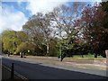
Trees along the southern edge of St James Park
In early April, some are in leaf, others not.
Image: © Christine Johnstone
Taken: 11 Apr 2014
0.01 miles
2
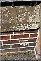
Benchmark(s) on wall of St James Park, north side of Norfolk Street
The mark in the bricks is an Ordnance Survey cut mark benchmark described on the Bench Mark Database at www.bench-marks.org.uk/bm68950. I don't know the significance of the mark on the coping stone
Image: © Roger Templeman
Taken: 19 Aug 2019
0.02 miles
3
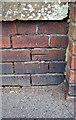
Benchmark on wall at entrance to St James Bowling Green
Ordnance Survey cut mark benchmark described on the Bench Mark Database at http://www.bench-marks.org.uk/bm68950
Image: © Roger Templeman
Taken: 7 Jul 2015
0.02 miles
4
Entrance to St James Bowling Green, Norfolk Street
There is an Ordnance Survey benchmark Image in the bricks on the wall left of the left hand gatepost. There appears to be another benchmark on the coping stone above the mark in the bricks Image
Image: © Roger Templeman
Taken: 7 Jul 2015
0.03 miles
5
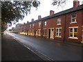
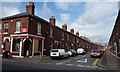
Terraced houses, Norfolk Street, Carlisle
A row of typical inner city 19th Century terraced houses on Norfolk Street.
Image: © Graham Robson
Taken: 30 Oct 2014
0.04 miles
6
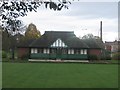
Bowls pavilion, St James' Park, Carlisle
The bowling green and its associated pavilion which form part of St James' Park in Carlisle.
Image: © Graham Robson
Taken: 30 Oct 2014
0.04 miles
7
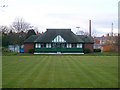
St. James Bowling Green
Situated in St. James Park, the bowling green opened in 1936.
Image: © Rose and Trev Clough
Taken: 6 Apr 2008
0.05 miles
8
Three Easter crosses at St James Church, Carlisle
Norfolk Street, not Golgotha.
Image: © Christine Johnstone
Taken: 11 Apr 2014
0.06 miles
9
Colville Street, Carlisle
Looking north from Norfolk Street.
Image: © Christine Johnstone
Taken: 11 Apr 2014
0.06 miles
10
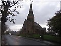
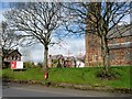
St James Church, St James Road, Carlisle
St James Church in the Longsowerby part of Carlisle. The church dates from around 1865 and was designed by Anderson and Pepper of Bradford. The building is grade II listed.
Image: © Graham Robson
Taken: 30 Oct 2014
0.06 miles