IMAGES TAKEN NEAR TO
Kangol Place, CARLISLE, CA2 5GX
Introduction
This page details the photographs taken nearby to Kangol Place, CA2 5GX by members of the Geograph project.
The Geograph project started in 2005 with the aim of publishing, organising and preserving representative images for every square kilometre of Great Britain, Ireland and the Isle of Man.

There are currently over 7.5m images from over14,400 individuals and you can help contribute to the project by visiting https://www.geograph.org.uk
Image Map
Images are licensed for reuse under creativecommons.org/licenses/by-sa/2.0
Notes
- Clicking on the map will re-center to the selected point.
- The higher the marker number, the further away the image location is from the centre of the postcode.
Image Listing (81 Images Found)
Images are licensed for reuse under creativecommons.org/licenses/by-sa/2.0
Image
Details
Distance
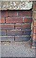
1
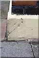
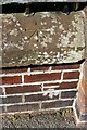
Benchmark on skirt of #26 Norfolk Street
Ordnance Survey pivot benchmark described on the Bench Mark Database at http://www.bench-marks.org.uk/bm68715
Image: © Roger Templeman
Taken: 7 Jul 2015
0.04 miles
2
Junction of Norfolk Street and Colville Street
There is an OS benchmark Image on the white skirt on the corner, right hand face, of the nearest house
Image: © Roger Templeman
Taken: 7 Jul 2015
0.05 miles
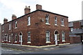
3
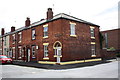
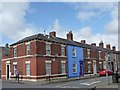
Terraced houses, Norfolk Street, Carlisle
A row of typical inner city 19th Century terraced houses on Norfolk Street.
Image: © Graham Robson
Taken: 30 Oct 2014
0.05 miles
4
Norfolk Court, Norfolk Street, Carlisle
Former business premises? Now flats and retail units.
Image: © Christine Johnstone
Taken: 11 Apr 2014
0.05 miles
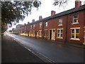
5
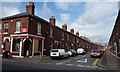
Houses on Westmorland Street at Norfolk Street junction
Image: © Roger Templeman
Taken: 7 Jul 2015
0.06 miles
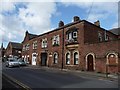
6
Colville Street, Carlisle
Looking north from Norfolk Street.
Image: © Christine Johnstone
Taken: 11 Apr 2014
0.06 miles
7
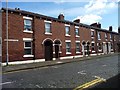
Westmorland Street, Carlisle
Looking south from Norfolk Street.
Image: © Christine Johnstone
Taken: 11 Apr 2014
0.06 miles
8
Benchmark on wall at entrance to St James Bowling Green
Ordnance Survey cut mark benchmark described on the Bench Mark Database at http://www.bench-marks.org.uk/bm68950
Image: © Roger Templeman
Taken: 7 Jul 2015
0.07 miles
9
Benchmark(s) on wall of St James Park, north side of Norfolk Street
The mark in the bricks is an Ordnance Survey cut mark benchmark described on the Bench Mark Database at www.bench-marks.org.uk/bm68950. I don't know the significance of the mark on the coping stone
Image: © Roger Templeman
Taken: 19 Aug 2019
0.07 miles
10
Westmorland Street, Carlisle
Somebody likes to be noticed. Looking north from Norfolk Street.
Image: © Christine Johnstone
Taken: 11 Apr 2014
0.07 miles