IMAGES TAKEN NEAR TO
Hewson Street, CARLISLE, CA2 5AU
Introduction
This page details the photographs taken nearby to Hewson Street, CA2 5AU by members of the Geograph project.
The Geograph project started in 2005 with the aim of publishing, organising and preserving representative images for every square kilometre of Great Britain, Ireland and the Isle of Man.

There are currently over 7.5m images from over14,400 individuals and you can help contribute to the project by visiting https://www.geograph.org.uk
Image Map
Images are licensed for reuse under creativecommons.org/licenses/by-sa/2.0
Notes
- Clicking on the map will re-center to the selected point.
- The higher the marker number, the further away the image location is from the centre of the postcode.
Image Listing (766 Images Found)
Images are licensed for reuse under creativecommons.org/licenses/by-sa/2.0
Image
Details
Distance
1
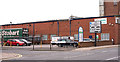
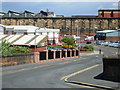
Site of "London & North Western Railway Inn" - June 2017
Situated on the corner of James Street at Hewson Street, the pub was built between 1843 and 1853. Initially names "St Stephen's Inn" after a nearby Church, the name was changed in 1875 after complaints by the local Clergy.
The pub was acquired by the State Management Scheme on 5 August 1916 and closed on 2 October 1938 on the opening of the rebuilt "Cumberland Wrestlers".
A sketch of the pub may be found: http://closedpubs.co.uk/cumberland/carlisle_londonnwr.html
The date of demolition has not yet been traced.
Photograph is for record only I have no connection with any business seen in this view and cannot advise on their products or services.
Image: © The Carlisle Kid
Taken: 14 Jun 2017
0.03 miles
2
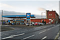
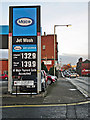
James Street Service Station
Petrol filling station with a convenience store and used car sales.
The business is on the site of the former St Stephen's Church, a substantial Gothic-style building consecrated in 1865 and demolished 99 years later (more information at Carlisle Encyclopaedia http://www.carlisleshistory.co.uk/page42.htm ) . A photo of the church can be seen at Cumbria Image Bank https://www.hpacde.org.uk/cumbria/jpgh/ct01708.jpg (C.I.B. main page : http://cumbriaimagebank.org.uk ).
Image: © Rose and Trev Clough
Taken: 26 Dec 2013
0.03 miles
3
St Stephen's Street, St Stephen's Day
View towards the top of James Street, with Carlisle Cathedral in the distance.
Image: © Rose and Trev Clough
Taken: 26 Dec 2013
0.04 miles
4
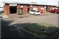
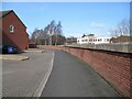
Industrial units on NW side of Rome Street
Ordnance Survey records indicate that a benchmark levelled at 16.357m above Newlyn Datum was verified in 1972 on No. 8 Rome Street previously at this location
Image: © Roger Templeman
Taken: 19 Aug 2019
0.04 miles
5
Rome Street, Carlisle
Seen from the railway bridge; beyond the wall is Citadel station.
Image: © Stephen McKay
Taken: 20 Jun 2008
0.05 miles
6
The Cumbria Way, Dentonholme
This unimaginatively designed bleak urban space is the route of the Caldew Cycleway and The Cumbria Way, alongside the high flood defence barrier which hides the River Caldew from view (next photograph Image).
Image: © Adrian Taylor
Taken: 11 Mar 2019
0.07 miles
7
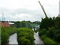
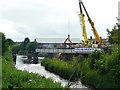
River Caldew, view upstream from Nelson Bridge
The cranes were set up in June 2008 to dismantle the damaged rail bridge upstream Image The work was being carried out as part of a flood alleviation scheme, to improve flow in the river.
The buildings on the left bank are the Crown Speciality Packaging factory (formerly Metal Box).
Image: © Rose and Trev Clough
Taken: 19 Jun 2008
0.07 miles
8
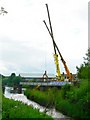
Caldew Railway Bridge - last chance to see
The bridge has stood like this since 1984, when half of it was demolished by a train crash. The incident occurred when some wagons became detached from a train and were freewheeling towards Carlisle Station. A quick-thinking signalman managed to divert them onto this line, which was opened in 1877 specifically for goods traffic, to avoid it going through the Station.
For more information on this railway see http://www.cumbria-railways.co.uk/bog_junction_carlisle.html .
Image: © Rose and Trev Clough
Taken: 19 Jun 2008
0.07 miles
9
Bridge demolition in progress
Image: © Rose and Trev Clough
Taken: 19 Jun 2008
0.07 miles
10
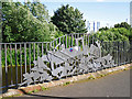
Sculptured railings beside the River Caldew
New flood walls were built along this stretch of the River Caldew in about 2008, set a few metres back from the bank. Some of the old walls were replaced with railings, which both enhance the view and allow rising water to spread over the cyclepath.
The decorative railings, created by Alan Dawson Associates of Workington, were inspired by Carlisle's railway heritage. This sculpture depicts a train crash which wrecked a nearby railway bridge in 1984 (see Image ).
The blue and red circular motif attached to the engine is part of another artwork, comprising 40 enamel plaques dotted around the city's flood defences (see Image ). It is a weather map of the British Isles dated 08/01/05 - the day that large areas of Carlisle suffered devastating floods.
Image: © Rose and Trev Clough
Taken: 1 Aug 2015
0.07 miles