IMAGES TAKEN NEAR TO
James Street, CARLISLE, CA2 5AH
Introduction
This page details the photographs taken nearby to James Street, CA2 5AH by members of the Geograph project.
The Geograph project started in 2005 with the aim of publishing, organising and preserving representative images for every square kilometre of Great Britain, Ireland and the Isle of Man.

There are currently over 7.5m images from over14,400 individuals and you can help contribute to the project by visiting https://www.geograph.org.uk
Image Map
Images are licensed for reuse under creativecommons.org/licenses/by-sa/2.0
Notes
- Clicking on the map will re-center to the selected point.
- The higher the marker number, the further away the image location is from the centre of the postcode.
Image Listing (741 Images Found)
Images are licensed for reuse under creativecommons.org/licenses/by-sa/2.0
Image
Details
Distance
1
St Stephen's Street, St Stephen's Day
View towards the top of James Street, with Carlisle Cathedral in the distance.
Image: © Rose and Trev Clough
Taken: 26 Dec 2013
0.01 miles
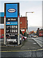
2
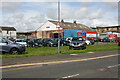
James Street Service Station
Petrol filling station with a convenience store and used car sales.
The business is on the site of the former St Stephen's Church, a substantial Gothic-style building consecrated in 1865 and demolished 99 years later (more information at Carlisle Encyclopaedia http://www.carlisleshistory.co.uk/page42.htm ) . A photo of the church can be seen at Cumbria Image Bank https://www.hpacde.org.uk/cumbria/jpgh/ct01708.jpg (C.I.B. main page : http://cumbriaimagebank.org.uk ).
Image: © Rose and Trev Clough
Taken: 26 Dec 2013
0.02 miles
3
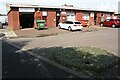
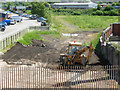
Industrial units on NW side of Rome Street
Ordnance Survey records indicate that a benchmark levelled at 16.357m above Newlyn Datum was verified in 1972 on No. 8 Rome Street previously at this location
Image: © Roger Templeman
Taken: 19 Aug 2019
0.03 miles
4
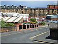
Rome Street, Carlisle
Seen from the railway bridge; beyond the wall is Citadel station.
Image: © Stephen McKay
Taken: 20 Jun 2008
0.03 miles
5
Former "Cumberland Wrestlers" - June 2017
The original "Cumberland Wrestlers" was built on this site 1875/76 and came under State Management control on 23 August 1916. It was demolished in 1937 and replaced by this Harry Redfern designed building, which opened on 3 October 1938. Sold to Scottish & Newcastle on 16 April 1973, the pub closed in 2004. With permission from the staff, an inspection of the ground floor revealed no trace of any pub fittings.
Photograph is for record only - I have no connection with any business seen in this view and cannot advise on their products or services.
Image: © The Carlisle Kid
Taken: 14 Jun 2017
0.04 miles
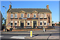
6
Site of "London & North Western Railway Inn" - June 2017
Situated on the corner of James Street at Hewson Street, the pub was built between 1843 and 1853. Initially names "St Stephen's Inn" after a nearby Church, the name was changed in 1875 after complaints by the local Clergy.
The pub was acquired by the State Management Scheme on 5 August 1916 and closed on 2 October 1938 on the opening of the rebuilt "Cumberland Wrestlers".
A sketch of the pub may be found: http://closedpubs.co.uk/cumberland/carlisle_londonnwr.html
The date of demolition has not yet been traced.
Photograph is for record only I have no connection with any business seen in this view and cannot advise on their products or services.
Image: © The Carlisle Kid
Taken: 14 Jun 2017
0.04 miles
7
Currock Street, Carlisle - March 2018
Only the south side survives of Victorian Currock Street - but it gives some indication of the density of pubs in Carlisle in 1916. To the right can be seen the former "Cumberland Wrestlers" (see: Image] ) while at far left is the long closed "Moulders Arms" (see: Image] ). Behind me would have been the "Oddfellows Inn" (see: Image] ) while a few minutes walk north from the "Moulders Arms" was the "Goliah/Goliath Inn" (see: Image] ).
Image: © The Carlisle Kid
Taken: 26 Mar 2018
0.05 miles
8
Fireplace Showroom, Carlisle
Crown Fireplaces, Crown Street, Carlisle.
Image: © Wayland Smith
Taken: 25 May 2013
0.07 miles
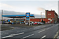
9
Border City Autos on NW side of Crown Street
Ordnance Survey records indicate that a benchmark levelled at 17.569m above Newlyn Datum was verified in 1972 on Building 26 previously at this location
Image: © Roger Templeman
Taken: 19 Aug 2019
0.08 miles
10
Rome Street Junction
Seen from the Rome Street Bridge, this was once the site of Rome Street Junction on the Carlisle avoiding lines, which gave freight trains an alternative route missing Citadel station, part of the complex railway layout around Carlisle. See http://www.cumbria-railways.co.uk/bog_junction_carlisle.html for details of the history of this railway. Network Rail has recently raised the possibility of reinstating this route to relieve congestion in the station.
Image: © Stephen McKay
Taken: 20 Jun 2008
0.08 miles