IMAGES TAKEN NEAR TO
CA2 5AA
Introduction
This page details the photographs taken nearby to CA2 5AA by members of the Geograph project.
The Geograph project started in 2005 with the aim of publishing, organising and preserving representative images for every square kilometre of Great Britain, Ireland and the Isle of Man.

There are currently over 7.5m images from over14,400 individuals and you can help contribute to the project by visiting https://www.geograph.org.uk
Image Map
Images are licensed for reuse under creativecommons.org/licenses/by-sa/2.0
Notes
- Clicking on the map will re-center to the selected point.
- The higher the marker number, the further away the image location is from the centre of the postcode.
Image Listing (656 Images Found)
Images are licensed for reuse under creativecommons.org/licenses/by-sa/2.0
Image
Details
Distance
1
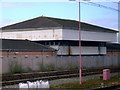
Signal box at Carlisle
To the south of Carlisle station. Appears to be disused.
Image: © Thomas Nugent
Taken: 28 Feb 2011
0.02 miles
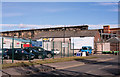
2
Maryport and Carlisle Railway Goods and Coal Depot
On Crown Street, viewed from Carlisle railway station.
Image: © Thomas Nugent
Taken: 3 Jan 2015
0.03 miles
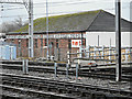
3
Carlisle Signal Box
The signal box at Carlisle Citadel Station.
Image: © Peter McDermott
Taken: 23 Jul 2014
0.03 miles
4
Site of "Goliah/Goliath Inn" - March 2018
Situated on the corner of Crown Street and Robert Street (where the cars are parked), the "Goliah Inn" dated from 1842-48 and took its name from a locomotive on the Newcastle & Carlisle Railway. Period photographs show the name clearly as "Goliah Inn", but it is not known if this apparent spelling error simply reflected the name applied to the locomotive. Period photographs also show the name was eventually changed to "Goliath Inn".
A 1901/02 view of this pub may be found: http://closedpubs.co.uk/cumberland/carlisle_goliah.html
The "Goliath Inn" was acquired by the State Management Scheme on 29 August 1916 and was converted to a food tavern, reopening on 18 June 1917. However, it closed in 1938 due to the opening of the nearby Redfern designed "Cumberland Wrestlers" (see: Image] ). Date of demolition has not been found, but it appears to have survived until at least 1991.
Photograph is for record only – I have no connection with any business seen in this view and cannot advise on their products or services.
Image: © The Carlisle Kid
Taken: 9 Mar 2018
0.03 miles
5
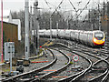
Carlisle railway station
A Virgin pendolino approaching from the south.
Image: © Thomas Nugent
Taken: 3 Jan 2015
0.03 miles
6
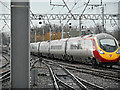
Carlisle railway station
A Virgin pendolino approaching from the south.
Image: © Thomas Nugent
Taken: 3 Jan 2015
0.04 miles
7
Steaming into Carlisle
Scots Guardsman nearing its destination at Carlisle. http://en.wikipedia.org/wiki/Carlisle_railway_station.
Image: © Ashley Dace
Taken: 9 Oct 2010
0.04 miles
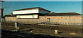
8
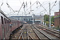
Carlisle station, view to the south - December 2016
One for the members of a Belfast camera club who thought my railway photographs would be much improved without the trains!
Image: © The Carlisle Kid
Taken: 3 Dec 2016
0.04 miles
9
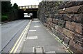
View along Crown Street towards railway bridge
There is an Ordnance Survey benchmark Image on a stone in the wall at the right foreground
Image: © Roger Templeman
Taken: 19 Aug 2019
0.05 miles
10
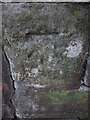
Ordnance Survey Cut Mark
This OS cut mark can be found on the NW side of Crown Street. It marks a point 16.603m above mean sea level.
Image: © Adrian Dust
Taken: 12 Apr 2016
0.05 miles