IMAGES TAKEN NEAR TO
Whitehaven Road, CLEATOR MOOR, CA25 5RJ
Introduction
This page details the photographs taken nearby to Whitehaven Road, CA25 5RJ by members of the Geograph project.
The Geograph project started in 2005 with the aim of publishing, organising and preserving representative images for every square kilometre of Great Britain, Ireland and the Isle of Man.

There are currently over 7.5m images from over14,400 individuals and you can help contribute to the project by visiting https://www.geograph.org.uk
Image Map
Images are licensed for reuse under creativecommons.org/licenses/by-sa/2.0
Notes
- Clicking on the map will re-center to the selected point.
- The higher the marker number, the further away the image location is from the centre of the postcode.
Image Listing (11 Images Found)
Images are licensed for reuse under creativecommons.org/licenses/by-sa/2.0
Image
Details
Distance
1
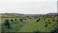
Near site of Cleator Moor station, 1986
A view along the course of the former Cleator & Workington Junction line, which was built, along with various other lines, for transporting haematite iron ore from the rich mines in the area to the iron and steel works in the Workington and Harrington Districts. For 100 years from the 1860s this area, nowadays almost reclaimed by nature, had been heavily industrialised and honeycombed by railways: the remnants of spoil-heaps from the iron and coal mines can be seen on the horizon. Keekle Viaduct can also be seen in the extreme left background.
Image: © Ben Brooksbank
Taken: 8 Jul 1986
0.09 miles
2
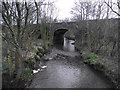
Keekle Low Bridge
Keekle Low Bridge carries the B5295 over the River Keekle
Image: © Tim Glover
Taken: 31 Dec 2012
0.16 miles
3
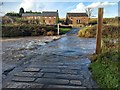
Keekle Ford
Looking towards Millhill Farm. The ford is an unattractive prospect in comparison with: http://www.geograph.org.uk/photo/4387418
Image: © David Medcalf
Taken: 10 Nov 2018
0.17 miles
4
Keekle Ford
This ford on the River Keekle is found at Keekle.
https://youtu.be/YpPmZAMMhAA
A much better photograph can be viewed at:
https://www.geograph.org.uk/photo/5988043
Image: © John Walton
Taken: 9 Mar 2015
0.17 miles
5
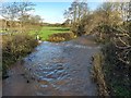
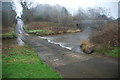
The River Keekle in spate
Taken from the footbridge next to the ford.
Image: © David Medcalf
Taken: 10 Nov 2018
0.17 miles
6
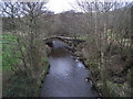
Old Keekle Bridge
The Old Keekle Bridge is a packhorse bridge over the River Keekle and was restored in 1994.
Image: © Tim Glover
Taken: 31 Dec 2012
0.19 miles
7
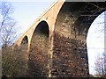
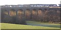
Keekle Viaduct.
A real tangle in the undergrowth down here.
Image: © John Holmes
Taken: 27 Dec 2005
0.23 miles
8
Keekle Viaduct.
Catching the sunlight from the eastern side.
Image: © John Holmes
Taken: 27 Dec 2005
0.23 miles
9
Keekle Viaduct.
The view over the nicely kept farmland on this eastern side is in complete contrast to the undergrowth on the other side. The row of houses behind is Keekle.
Image: © John Holmes
Taken: 27 Dec 2005
0.23 miles
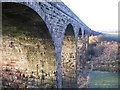
10
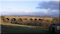
Keekle Viaduct.
Built in 1878 and in this view has the overgrown area in front and the Lake District fells in the background.
Image: © John Holmes
Taken: 27 Dec 2005
0.23 miles