IMAGES TAKEN NEAR TO
Durdar Road, CARLISLE, CA2 4SU
Introduction
This page details the photographs taken nearby to Durdar Road, CA2 4SU by members of the Geograph project.
The Geograph project started in 2005 with the aim of publishing, organising and preserving representative images for every square kilometre of Great Britain, Ireland and the Isle of Man.

There are currently over 7.5m images from over14,400 individuals and you can help contribute to the project by visiting https://www.geograph.org.uk
Image Map
Images are licensed for reuse under creativecommons.org/licenses/by-sa/2.0
Notes
- Clicking on the map will re-center to the selected point.
- The higher the marker number, the further away the image location is from the centre of the postcode.
Image Listing (45 Images Found)
Images are licensed for reuse under creativecommons.org/licenses/by-sa/2.0
Image
Details
Distance
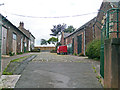
1
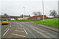
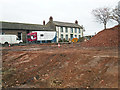
Demolition site, former racecourse stable complex
Compare with similar view when the buildings were still standing Image .
Image: © Rose and Trev Clough
Taken: 15 Nov 2017
0.02 miles
2
Disused stables and house at Carlisle Racecourse (2013)
The building behind the chevrons is one side of a rectangular yard, originally part of Blackwell House Farm. The block was converted to stabling when Carlisle Racecourse relocated here from the Swifts in 1904. The white house (No.68 Durdar Road) had been boarded up for some years when this photo was taken.
New stable facilities were opened at the southern end of the racecourse in 2006. These old buildings were redundant, and were demolished in autumn 2017 (see Image). The site will be redeveloped with housing.
Image: © Rose and Trev Clough
Taken: 9 Aug 2013
0.02 miles
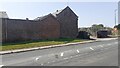
3
Former stables, Carlisle Racecourse (2013)
The south-eastern face of a rectangular stable complex.
Located opposite Blackwell House on Durdar Road. For information and a wider view of location, see Image .
Demolished in 2017.
Image: © Rose and Trev Clough
Taken: 9 Aug 2013
0.02 miles
4
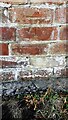
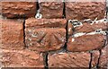
Benchmark on former stables on SW side of Durdar Road
Ordnance Survey cut mark benchmark
Image: © Roger Templeman
Taken: 21 Jul 2021
0.02 miles
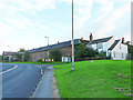
5
Blackwell House and stables, Durdar Road (2007)
Carlisle Racecourse moved from The Swifts to Blackwell House Farm in 1904.
The farmhouse, at the far left of the driveway, dates from about 1730. Together with some attached stables, it is a Grade II listed building - see Historic England for details https://historicengland.org.uk/listing/the-list/list-entry/1087744 .
The buildings on the right form one side of an enclosed rectangular yard, originally part of the farm. The block was converted to stables, and used by Carlisle Racecourse for about 100 years. Redundant when this picture was taken, the stables were demolished in 2017.
Image: © Rose and Trev Clough
Taken: 26 Aug 2007
0.03 miles
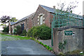
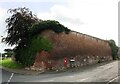
6
Former stables and entrance to Blackwell House on SW side Durdar Road
There is an Ordnance Survey benchmark Image on the brick wall about 5m left of the junction of the wall and the building in the middle of the image
Image: © Roger Templeman
Taken: 21 Jul 2021
0.04 miles
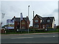
7
Building at junction of Lowry Street and Durdar Road
There is an Ordnance Survey benchmark Image on the rounded corner of the building
Image: © Luke Shaw
Taken: 28 Aug 2019
0.04 miles
9
Benchmark on building at corner of Lowry Street and Durdar Road
Ordnance Survey cut mark benchmark described on the Bench Mark Database at www.bench-marks.org.uk/bm103276
Image: © Luke Shaw
Taken: 28 Aug 2019
0.04 miles
10
Rubble from demolished stable complex opposite Blackwell House
For more information, see Image .
Blackwell House, built c. 1730, is a grade II listed building https://historicengland.org.uk/listing/the-list/list-entry/1087744 . It was used as headquarters by leaders of opposing sides in the Jacobite rising of 1745 - Bonnie Prince Charlie stayed here on 10 November, and the Duke of Cumberland from 21-31 December.
Image: © Rose and Trev Clough
Taken: 15 Nov 2017
0.04 miles