IMAGES TAKEN NEAR TO
Huntingdon Lane, CARLISLE, CA2 4QZ
Introduction
This page details the photographs taken nearby to Huntingdon Lane, CA2 4QZ by members of the Geograph project.
The Geograph project started in 2005 with the aim of publishing, organising and preserving representative images for every square kilometre of Great Britain, Ireland and the Isle of Man.

There are currently over 7.5m images from over14,400 individuals and you can help contribute to the project by visiting https://www.geograph.org.uk
Image Map
Images are licensed for reuse under creativecommons.org/licenses/by-sa/2.0
Notes
- Clicking on the map will re-center to the selected point.
- The higher the marker number, the further away the image location is from the centre of the postcode.
Image Listing (46 Images Found)
Images are licensed for reuse under creativecommons.org/licenses/by-sa/2.0
Image
Details
Distance
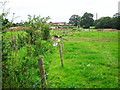
1
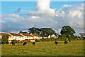
Cattle in field behind Oaklands Drive (2007)
View from public footpath.
Zoom shot.
Image: © Rose and Trev Clough
Taken: 12 Aug 2007
0.05 miles
2
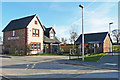
Show home, The Ridings
This is phase 2 of The Ridings development https://www.storyhomes.co.uk/developments/the-ridings/ which will eventually comprise more than 300 homes.
Image: © Rose and Trev Clough
Taken: 20 Mar 2018
0.06 miles
3

Path following field edge (2007)
View to the rear of houses in Scalegate Road (L) and Oaklands Drive (R).
Behind the fence is a drainage ditch, which feeds into Wire Mire Beck.
Image: © Rose and Trev Clough
Taken: 12 Aug 2007
0.07 miles
4
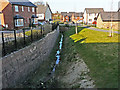
Drainage channel
Between recently constructed houses at The Ridings. This follows the line of a pre-existing ditch along a former field margin. Further ahead the old ditch took a 45 degree turn to the north east (see Image ), but a new straight course has been dug to take the flow in a northerly direction.
The tower of St Margaret Mary's Catholic Church (Scalegate Road) is visible in the distance.
Image: © Rose and Trev Clough
Taken: 20 Mar 2018
0.08 miles
5
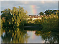
Rainbow at Hammonds Pond
Evening sun shining on Oaklands Drive.
Zoom shot.
Image: © Rose and Trev Clough
Taken: 12 Aug 2007
0.08 miles
6
Drainage ditch adjacent to old footpath (2014)
Houses under construction at 'The Ridings' development can be seen in the distance.
Image: © Rose and Trev Clough
Taken: 25 Aug 2014
0.08 miles
7

Farm track between Blackwell and Upperby (2007)
Heading east. For a view further along, see Image .
Not a right of way.
Image: © Rose and Trev Clough
Taken: 12 Aug 2007
0.09 miles
8

Gate on old footpath (2014)
The footpath follows the line of a hedge and ditch.
Image: © Rose and Trev Clough
Taken: 25 Aug 2014
0.10 miles
9
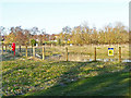
SUDS pond at The Ridings
SUDS stands for sustainable urban drainage system - for information see Wikipedia article https://en.wikipedia.org/wiki/Sustainable_drainage_system .
The pond has been created to contain surface water runoff from the housing estate
Image: © Rose and Trev Clough
Taken: 20 Mar 2018
0.10 miles
10
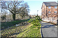
Ditch and footpath at The Ridings
The path should eventually continue through to the eastern end of Hammonds Pond, but at this stage there was no access to the park from the new housing estate. An old public footpath between Blackwell and Upperby was diverted to enable development of The Ridings - see for example Image .
Image: © Rose and Trev Clough
Taken: 20 Mar 2018
0.10 miles