IMAGES TAKEN NEAR TO
Haydock Drive, CARLISLE, CA2 4QY
Introduction
This page details the photographs taken nearby to Haydock Drive, CA2 4QY by members of the Geograph project.
The Geograph project started in 2005 with the aim of publishing, organising and preserving representative images for every square kilometre of Great Britain, Ireland and the Isle of Man.

There are currently over 7.5m images from over14,400 individuals and you can help contribute to the project by visiting https://www.geograph.org.uk
Image Map
Images are licensed for reuse under creativecommons.org/licenses/by-sa/2.0
Notes
- Clicking on the map will re-center to the selected point.
- The higher the marker number, the further away the image location is from the centre of the postcode.
Image Listing (52 Images Found)
Images are licensed for reuse under creativecommons.org/licenses/by-sa/2.0
Image
Details
Distance
1
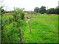
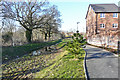
Drainage ditch adjacent to old footpath (2014)
Houses under construction at 'The Ridings' development can be seen in the distance.
Image: © Rose and Trev Clough
Taken: 25 Aug 2014
0.02 miles
2

Gate on old footpath (2014)
The footpath follows the line of a hedge and ditch.
Image: © Rose and Trev Clough
Taken: 25 Aug 2014
0.03 miles
3
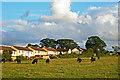
Cattle in field behind Oaklands Drive (2007)
View from public footpath.
Zoom shot.
Image: © Rose and Trev Clough
Taken: 12 Aug 2007
0.04 miles
4
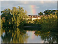
Rainbow at Hammonds Pond
Evening sun shining on Oaklands Drive.
Zoom shot.
Image: © Rose and Trev Clough
Taken: 12 Aug 2007
0.05 miles
5

Path following field edge (2007)
View to the rear of houses in Scalegate Road (L) and Oaklands Drive (R).
Behind the fence is a drainage ditch, which feeds into Wire Mire Beck.
Image: © Rose and Trev Clough
Taken: 12 Aug 2007
0.05 miles
6

Enclosed footpath at Upperby (2014)
Bungalows in Oaklands Drive are behind the wooden fence. A paddock is on the right.
Care was needed to avoid stepping in something unpleasant.
Image: © Rose and Trev Clough
Taken: 25 Aug 2014
0.06 miles
7
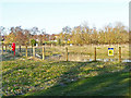
SUDS pond at The Ridings
SUDS stands for sustainable urban drainage system - for information see Wikipedia article https://en.wikipedia.org/wiki/Sustainable_drainage_system .
The pond has been created to contain surface water runoff from the housing estate
Image: © Rose and Trev Clough
Taken: 20 Mar 2018
0.07 miles
8

Overgrown footpath at Upperby (2014)
Probably not much used at this stage, as a stopping up order had been issued in April 2014. Preparation for building work had begun further back along the route.
Behind the metal fence are a house and stable, set back from Scalegate Road.
Image: © Rose and Trev Clough
Taken: 25 Aug 2014
0.07 miles
9
Ditch and footpath at The Ridings
The path should eventually continue through to the eastern end of Hammonds Pond, but at this stage there was no access to the park from the new housing estate. An old public footpath between Blackwell and Upperby was diverted to enable development of The Ridings - see for example Image .
Image: © Rose and Trev Clough
Taken: 20 Mar 2018
0.08 miles
10
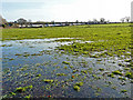
Waterlogged field near Hammonds Pond
View towards the back of houses in Oaklands Drive.
Image: © Rose and Trev Clough
Taken: 25 Dec 2013
0.09 miles