IMAGES TAKEN NEAR TO
Buchanan Road, CARLISLE, CA2 4QE
Introduction
This page details the photographs taken nearby to Buchanan Road, CA2 4QE by members of the Geograph project.
The Geograph project started in 2005 with the aim of publishing, organising and preserving representative images for every square kilometre of Great Britain, Ireland and the Isle of Man.

There are currently over 7.5m images from over14,400 individuals and you can help contribute to the project by visiting https://www.geograph.org.uk
Image Map
Images are licensed for reuse under creativecommons.org/licenses/by-sa/2.0
Notes
- Clicking on the map will re-center to the selected point.
- The higher the marker number, the further away the image location is from the centre of the postcode.
Image Listing (51 Images Found)
Images are licensed for reuse under creativecommons.org/licenses/by-sa/2.0
Image
Details
Distance
2
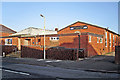
St Margaret Mary's Social Club
The club is adjacent to the Roman Catholic parish church in Scalegate Road.
Image: © Rose and Trev Clough
Taken: 26 Dec 2013
0.11 miles
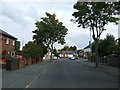
3
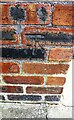
Benchmark on No. 1 Henderson Road
Ordnance Survey cut mark benchmark described on the Bench Mark Database at www.bench-marks.org.uk/bm103410
Image: © Luke Shaw
Taken: 28 Aug 2019
0.12 miles
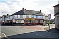
4
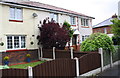
#40 Ridley Road
The house has been extended on its east face obliterating an Ordnance Survey benchmark described as 'CUT MARK NO40 RIDLEY RD E FACE SE ANG 35.646m above Newlyn Datum'
Image: © Roger Templeman
Taken: 20 May 2017
0.12 miles
5
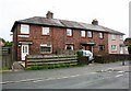
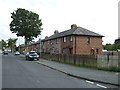
Nos. 1, 3, 5 and 7 Henderson Road
There is an Ordnance Survey benchmark Image on the side of the left hand house at its front corner
Image: © Luke Shaw
Taken: 28 Aug 2019
0.12 miles
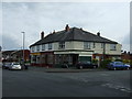
8
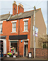
Ridley Road shops
McCalls Bakers & Confectioners, Sunny Fish & Chicken Bar (Chinese take away) and Country Shop (fruit & veg, general store). Taken on a sunday.
The nearer building on the right, now a private house, used to be a newsagents (last appears on Google Street View in 2009 https://goo.gl/maps/WBjPQeyFvyJ2 ).
Image: © Rose and Trev Clough
Taken: 2 Oct 2016
0.14 miles
9
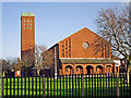
St Margaret Mary's Catholic Church, Upperby
The parish was founded in 1933. The present church in Scalegate Road opened in 1961.
Image: © Rose and Trev Clough
Taken: 26 Dec 2013
0.15 miles
10
Florist, Millholme Avenue, Carlisle - March 2017
A small florists shop in an extension of The Currock building, which may have been The Currock Wine Stores, an off-sales shop to the Currock Inn - see: Image] .
Image: © The Carlisle Kid
Taken: 8 Mar 2017
0.15 miles