IMAGES TAKEN NEAR TO
Scalegate Road, CARLISLE, CA2 4PJ
Introduction
This page details the photographs taken nearby to Scalegate Road, CA2 4PJ by members of the Geograph project.
The Geograph project started in 2005 with the aim of publishing, organising and preserving representative images for every square kilometre of Great Britain, Ireland and the Isle of Man.

There are currently over 7.5m images from over14,400 individuals and you can help contribute to the project by visiting https://www.geograph.org.uk
Image Map (Loading...)


Getting Data...Please wait
Leaflet Map data © OpenStreetMap
Images are licensed for reuse under creativecommons.org/licenses/by-sa/2.0
Notes
- Clicking on the map will re-center to the selected point.
- The higher the marker number, the further away the image location is from the centre of the postcode.
Image Listing (56 Images Found)
Images are licensed for reuse under creativecommons.org/licenses/by-sa/2.0
Image
Details
Distance
1
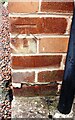
Benchmark on No. 230 Scalegate Road
Ordnance Survey cut mark benchmark described on the Bench Mark Database at www.bench-marks.org.uk/bm103413
Image: © Luke Shaw
Taken: 1 Sep 2020
0.01 miles
2
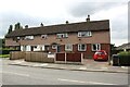
Row of houses on SW side of Scalegate Road
There is an Ordnance Survey benchmark Image on the side of the right hand house at its front corner
Image: © Luke Shaw
Taken: 1 Sep 2020
0.02 miles
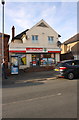
4
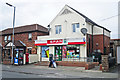
SPAR shop, Lamb Street, Upperby
There was a Post Office here for many years, but it was closed during a round of branch cutting in 2008.
Image: © Rose and Trev Clough
Taken: 25 Aug 2014
0.03 miles
5

Start of footpath to Blackwell (2014)
Access to public footpath alongside the driveway to a private property, off Scalegate Road. This location is named 'Armstrong's Place' on an OS map from 1925 - see https://www.old-maps.co.uk/#/Map/340886/553314/12/101238 .
Bungalows in Oaklands Drive are behind the fence on the left.
Image: © Rose and Trev Clough
Taken: 25 Aug 2014
0.03 miles
6
Commemorative stone, Upperby Institute
On the wall of the car park - for location see Image .
Image: © Rose and Trev Clough
Taken: 25 Aug 2014
0.04 miles
7
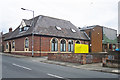
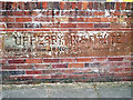
Upperby Men's Institute
A social club in Lamb Street.
Opened on December 26th 1922 by Alderman J.W. Nicholson J.P. - see Image .
Image: © Rose and Trev Clough
Taken: 25 Aug 2014
0.05 miles
8
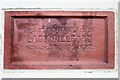
Stone laid by Lady Gillford at Upperby Institute
Dated November 8th 1922. Amongst other plaques laid by local dignitaries, located on the front of the building shown here Image .
Lady Gillford lived at Petteril Bank Image .
Image: © Rose and Trev Clough
Taken: 25 Aug 2014
0.05 miles
9

Overgrown footpath at Upperby (2014)
Probably not much used at this stage, as a stopping up order had been issued in April 2014. Preparation for building work had begun further back along the route.
Behind the metal fence are a house and stable, set back from Scalegate Road.
Image: © Rose and Trev Clough
Taken: 25 Aug 2014
0.05 miles
10

Enclosed footpath at Upperby (2014)
Bungalows in Oaklands Drive are behind the wooden fence. A paddock is on the right.
Care was needed to avoid stepping in something unpleasant.
Image: © Rose and Trev Clough
Taken: 25 Aug 2014
0.06 miles