IMAGES TAKEN NEAR TO
Cammock Crescent, CARLISLE, CA2 4PE
Introduction
This page details the photographs taken nearby to Cammock Crescent, CA2 4PE by members of the Geograph project.
The Geograph project started in 2005 with the aim of publishing, organising and preserving representative images for every square kilometre of Great Britain, Ireland and the Isle of Man.

There are currently over 7.5m images from over14,400 individuals and you can help contribute to the project by visiting https://www.geograph.org.uk
Image Map
Images are licensed for reuse under creativecommons.org/licenses/by-sa/2.0
Notes
- Clicking on the map will re-center to the selected point.
- The higher the marker number, the further away the image location is from the centre of the postcode.
Image Listing (30 Images Found)
Images are licensed for reuse under creativecommons.org/licenses/by-sa/2.0
Image
Details
Distance
1
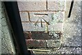
Benchmark on No. 50 Brisco Road
Ordnance Survey cut mark benchmark described on the Bench Mark Database at www.bench-marks.org.uk/bm103216
Image: © Luke Shaw
Taken: 24 Aug 2019
0.10 miles
2
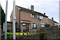
Nos. 50 & 48 Brisco Road
There is an Ordnance Survey benchmark Image on the side of the left hand house at its front corner, right of a wheelie bin
Image: © Luke Shaw
Taken: 24 Aug 2019
0.10 miles
3
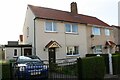
Nos. 26 & 24 Brisco Road
Ordnance Survey documents indicate that a benchmark levelled at 36.235m above Newlyn Datum was verified in 1972 on the now pebbledashed left hand house at its front left hand corner. See www.bench-marks.org.uk/bm103215
Image: © Luke Shaw
Taken: 24 Aug 2019
0.14 miles
4
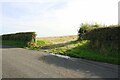
Field access from SW side of Brisco Road
Ordnance Survey documents indicate that a benchmark levelled at 53.381m above Newlyn Datum was verified on a gatepost at this location in 1972
Image: © Luke Shaw
Taken: 24 Aug 2019
0.17 miles
5
The River Petteril
Children playing by the river at the footbridge near Dicky Wood. Viewed from a Glasgow bound train.
Image: © Thomas Nugent
Taken: 18 Apr 2014
0.19 miles
6
The River Petteril
Children playing by the river at the footbridge near Dicky Wood. Viewed from a Glasgow bound train.
Image: © Thomas Nugent
Taken: 18 Apr 2014
0.19 miles
7
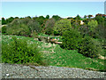
Above The River Petteril
Looking down to the flood plain from the high-level footpath on a bright mid-February morning.
Image: © Mary and Angus Hogg
Taken: 20 Feb 2018
0.19 miles
8
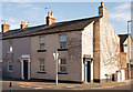
Former "Black Bull Inn", Upperby - October 2017
Appears on the 1867 OS Map and is probably mid-19th Century, the "Black Bull Inn" was acquired by the State Management Scheme on 16 August 1916. It probably closed when the nearby Redfern designed "Rose & Crown" opened on 22 December 1930 and has been a private dwelling since.
The OS Maps are vague and it is uncertain how much of this building was the "Black Bull", it could well have included part or all of the grey fronted property to the left.
Private dwellings with no public access.
Image: © The Carlisle Kid
Taken: 29 Oct 2017
0.22 miles
9
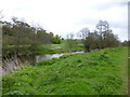
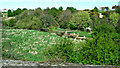
Carlisle, River Petteril
Looking upstream from the riverside walk.
Image: © Mike Faherty
Taken: 15 May 2012
0.22 miles
10
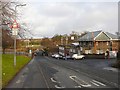
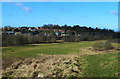
The road from Upperby to Harraby
St. Ninian's Road runs down towards Image Houses at Old Harraby can be seen on the far side of the valley.
Image: © Rose and Trev Clough
Taken: 13 Jan 2009
0.22 miles