IMAGES TAKEN NEAR TO
Upperby Road, CARLISLE, CA2 4HU
Introduction
This page details the photographs taken nearby to Upperby Road, CA2 4HU by members of the Geograph project.
The Geograph project started in 2005 with the aim of publishing, organising and preserving representative images for every square kilometre of Great Britain, Ireland and the Isle of Man.

There are currently over 7.5m images from over14,400 individuals and you can help contribute to the project by visiting https://www.geograph.org.uk
Image Map
Images are licensed for reuse under creativecommons.org/licenses/by-sa/2.0
Notes
- Clicking on the map will re-center to the selected point.
- The higher the marker number, the further away the image location is from the centre of the postcode.
Image Listing (34 Images Found)
Images are licensed for reuse under creativecommons.org/licenses/by-sa/2.0
Image
Details
Distance
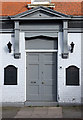
1
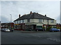
#1a Scalegate Road at Upperby Road junction
There is an OS benchmark Image at the centre of the right hand face of the nearest building, right of the white door and on the side of Denise's Unisex Salon
Image: © Roger Templeman
Taken: 20 May 2017
0.03 miles
2
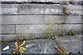
Benchmark on #1 Scalegate Road
Ordnance Survey cut mark benchmark described on the Bench Mark Database at http://www.bench-marks.org.uk/bm38689
Image: © Roger Templeman
Taken: 26 Jun 2011
0.03 miles
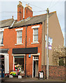
3
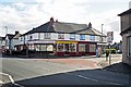
Ridley Road shops
McCalls Bakers & Confectioners, Sunny Fish & Chicken Bar (Chinese take away) and Country Shop (fruit & veg, general store). Taken on a sunday.
The nearer building on the right, now a private house, used to be a newsagents (last appears on Google Street View in 2009 https://goo.gl/maps/WBjPQeyFvyJ2 ).
Image: © Rose and Trev Clough
Taken: 2 Oct 2016
0.04 miles
5
The Currock, Boundary Road, Carlisle - March 2017 (2)
Entrance to the lounge - for information on this building, see: Image] .
Image: © The Carlisle Kid
Taken: 8 Mar 2017
0.05 miles
6
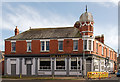
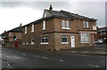
The Currock, Boundary Road, Carlisle - March 2017 (1)
Built in 1899 as the Currock Hotel, the building did not open until 1903 due to a dispute with the local temperance movement and the licencing authority. Taken under State Management in August 1916, the pub (then known as The Currock Inn) was part of a substantial lot sold to Greenall Whitley in April 1973. At one time noted as the only pub in the area with table bowls, the pub has been closed in recent years but is believed to be currently trading.
The story is told of an Irish "navvy" who, during the State Management era, felt he had been cheated by some customers of the Currock. He showed his displeasure by lifting the customer's table and flinging it in the fire. This somewhat impressed the locals as the table was made of cast iron and bolted to the floor!
See also: Image] and Image] .
Photograph is for record only - I have no connection with this business and cannot advise on its products or services.
Image: © The Carlisle Kid
Taken: 8 Mar 2017
0.05 miles
8
Florist, Millholme Avenue, Carlisle - March 2017
A small florists shop in an extension of The Currock building, which may have been The Currock Wine Stores, an off-sales shop to the Currock Inn - see: Image] .
Image: © The Carlisle Kid
Taken: 8 Mar 2017
0.07 miles
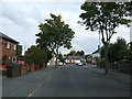
9
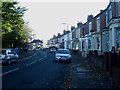
Terraced housing, Boundary Road, Carlisle
A curving row of terraced housing on Boundary Road, Carlisle. The grounds of Bishop Harvey Goodwin Primary School border the left hand side of the road.
Image: © Graham Robson
Taken: 3 Nov 2013
0.11 miles
10
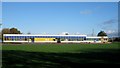
Bishop Harvey Goodwin Primary School, Carlisle
The Bishop Harvey Goodwin Primary School, located on Harold Street in Carlisle.
Image: © Graham Robson
Taken: 3 Nov 2013
0.12 miles