IMAGES TAKEN NEAR TO
Upperby Way, CARLISLE, CA2 4GJ
Introduction
This page details the photographs taken nearby to Upperby Way, CA2 4GJ by members of the Geograph project.
The Geograph project started in 2005 with the aim of publishing, organising and preserving representative images for every square kilometre of Great Britain, Ireland and the Isle of Man.

There are currently over 7.5m images from over14,400 individuals and you can help contribute to the project by visiting https://www.geograph.org.uk
Image Map
Images are licensed for reuse under creativecommons.org/licenses/by-sa/2.0
Notes
- Clicking on the map will re-center to the selected point.
- The higher the marker number, the further away the image location is from the centre of the postcode.
Image Listing (41 Images Found)
Images are licensed for reuse under creativecommons.org/licenses/by-sa/2.0
Image
Details
Distance
1
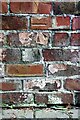
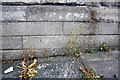
Benchmark on garage block at rear of No. 63 Upperby Road (Stapleton House)
Ordnance Survey cut mark benchmark levelled at 37.876m above Newlyn Datum verified in 1972. See www.bench-marks.org.uk/bm103222
Image: © Luke Shaw
Taken: 1 Sep 2020
0.03 miles
2
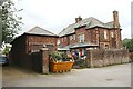
Garage block at rear of Nos. 63 and 65 Upperby Road
There is an Ordnance Survey benchmark Image on the garage block near the left hand edge of the image just beyond its junction with the abutting brick wall.
Image: © Luke Shaw
Taken: 1 Sep 2020
0.04 miles
4
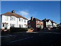
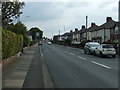
Semi detached houses, Upperby Road, Carlisle
Semi detached houses alongside Upperby Road in the Upperby suburb of Carlisle.
Image: © Graham Robson
Taken: 3 Nov 2013
0.07 miles
5
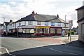
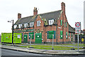
Ridley Road shops
McCalls Bakers & Confectioners, Sunny Fish & Chicken Bar (Chinese take away) and Country Shop (fruit & veg, general store). Taken on a sunday.
The nearer building on the right, now a private house, used to be a newsagents (last appears on Google Street View in 2009 https://goo.gl/maps/WBjPQeyFvyJ2 ).
Image: © Rose and Trev Clough
Taken: 2 Oct 2016
0.11 miles
7
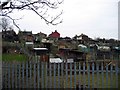
Currock chicken huts
A varied collection of sheds in these allotments seen on crossing the footbridge over the railway from Gildford Park to Currock. Most seem to house chickens.
Image: © Brian Norman
Taken: 3 Mar 2013
0.14 miles
8
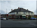
#1a Scalegate Road at Upperby Road junction
There is an OS benchmark Image at the centre of the right hand face of the nearest building, right of the white door and on the side of Denise's Unisex Salon
Image: © Roger Templeman
Taken: 20 May 2017
0.15 miles
9
Benchmark on #1 Scalegate Road
Ordnance Survey cut mark benchmark described on the Bench Mark Database at http://www.bench-marks.org.uk/bm38689
Image: © Roger Templeman
Taken: 26 Jun 2011
0.15 miles
10
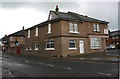
The Rose & Crown, Upperby, January 2013 (1)
Photo taken shortly before demolition.
An application to have the building listed was turned down by Historic England for the following principal reasons (quoted from report available here http://www.heritagegateway.org.uk/Gateway/Results_Single.aspx?uid=1412030&resourceID=7 ) :
* Architectural Interest: the vernacular style of the pub is typical rather than special and its appearance has been marred by the loss of the rendered exterior; * Alteration: there has been visual alteration to the exterior and structural alteration to the interior, with two former rooms opened out into one and the loggia enclosed; * Survival: very few original features, fixtures or fittings survive, being limited to a small amount of tiling and three first floor fireplaces; * Historic interest: the historic interest of the pub rests on its position as one of the family friendly pubs designed by Harry Redfern for the Carlisle State Management System, but better preserved examples survive and are protected
Image: © Rose and Trev Clough
Taken: 24 Jan 2013
0.15 miles