IMAGES TAKEN NEAR TO
Robinson Street, CARLISLE, CA2 4ES
Introduction
This page details the photographs taken nearby to Robinson Street, CA2 4ES by members of the Geograph project.
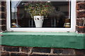
The Geograph project started in 2005 with the aim of publishing, organising and preserving representative images for every square kilometre of Great Britain, Ireland and the Isle of Man.

There are currently over 7.5m images from over14,400 individuals and you can help contribute to the project by visiting https://www.geograph.org.uk
Image Map
Images are licensed for reuse under creativecommons.org/licenses/by-sa/2.0
Notes
- Clicking on the map will re-center to the selected point.
- The higher the marker number, the further away the image location is from the centre of the postcode.
Image Listing (63 Images Found)
Images are licensed for reuse under creativecommons.org/licenses/by-sa/2.0
Image
Details
Distance
1
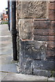
Benchmark on #2 Tithe Barn Street at junction with Salisbury Road
Ordnance Survey cut mark benchmark described on the Bench Mark Database at http://www.bench-marks.org.uk/bm38722
Image: © Roger Templeman
Taken: 26 Jun 2011
0.08 miles
2
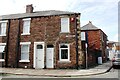
Houses at north end of Tithe Barn Street at Salisbury Road junction
There is an Ordnance Survey benchmark Image on the side of the right hand house (#2).
Image: © Luke Shaw
Taken: 1 Sep 2020
0.09 miles
3
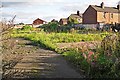
Site of demolished buildings, Regent Street
View through fence.
There used to be a NACRO training centre here. It was a modern construction - still standing in 2010 when Google Street View visited https://goo.gl/maps/HcfJ9YqW6r42 .
Image: © Rose and Trev Clough
Taken: 2 Oct 2016
0.09 miles
4
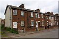
Houses at SW end of Hasell Street
There was an OS benchmark Image on the ground floor window sill of #2 (by the black wheelie bin).
Image: © Roger Templeman
Taken: 20 May 2017
0.09 miles
5
Lost benchmark on #2 Hasell Street
There should be an Ordnance Survey cut mark benchmark on the window sill but it appears to have been filled in and painted over (see http://www.bench-marks.org.uk/bm38379 )
Image: © Roger Templeman
Taken: 26 Jun 2011
0.10 miles
6
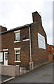
#17 Hasell Street at Regent Street junction
There is an OS benchmark Image on the far corner of the right hand face of house. The poster on this face is for John Stevenson conservative Member of Parliament for Carlisle.
Image: © Roger Templeman
Taken: 20 May 2017
0.10 miles
7
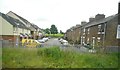
Hasell Street
Seen from a passing train.
Image: © Richard Sutcliffe
Taken: 5 Jun 2017
0.11 miles
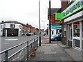
9
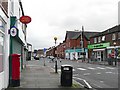
Currock Crossroads
Several local shops here, including a Post Office which survived the recent round of cuts. Sometimes referred to as Currock Cross or Five Road Ends.
Image: © Rose and Trev Clough
Taken: 7 Sep 2008
0.11 miles
10
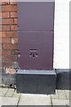
Benchmark on The Currock pub
Ordnance Survey cut mark benchmark described on the Bench Mark Database at http://www.bench-marks.org.uk/bm38721
Image: © Roger Templeman
Taken: 26 Jun 2011
0.12 miles