IMAGES TAKEN NEAR TO
Webster Crescent, CARLISLE, CA2 4DA
Introduction
This page details the photographs taken nearby to Webster Crescent, CA2 4DA by members of the Geograph project.
The Geograph project started in 2005 with the aim of publishing, organising and preserving representative images for every square kilometre of Great Britain, Ireland and the Isle of Man.

There are currently over 7.5m images from over14,400 individuals and you can help contribute to the project by visiting https://www.geograph.org.uk
Image Map
Images are licensed for reuse under creativecommons.org/licenses/by-sa/2.0
Notes
- Clicking on the map will re-center to the selected point.
- The higher the marker number, the further away the image location is from the centre of the postcode.
Image Listing (72 Images Found)
Images are licensed for reuse under creativecommons.org/licenses/by-sa/2.0
Image
Details
Distance
1
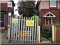
Closed footpath to former railway footbridge
Between houses on Lund Crescent.
The new footbridge starts some distance left of here, from an open grassed area opposite Currock House
Image: © Rose and Trev Clough
Taken: 18 Sep 2016
0.06 miles
2
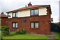
Nos. 62 and 64 Lediard Avenue
There is an OS benchmark Image on the right hand house at its front corner
Image: © Roger Templeman
Taken: 20 May 2017
0.07 miles
3
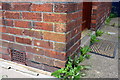
Benchmark on #62 Lediard Avenue
Ordnance Survey cut mark benchmark described on the Bench Mark Database at http://www.bench-marks.org.uk/bm38665
Image: © Roger Templeman
Taken: 26 Jun 2011
0.07 miles
4
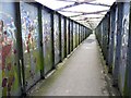
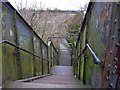
Currock railway footbridge (1) - the inside
This rusty metal bridge was built in 1929. It crosses the Cumbrian Coast railway line, between Currock and Denton Holme. It is seriously scary because you can't see if anybody else is on it as you approach, from either end. The sides are completely enclosed, and too high to see over the top. For other views of the bridge, see Geograph photos http://www.geograph.org.uk/photo/1197294 and http://www.geograph.org.uk/photo/1197293 .
Information update : This bridge was demolished in September 2016, after a much more user-friendly replacement was installed - see Image .
Image: © Rose and Trev Clough
Taken: 21 Feb 2009
0.08 miles
5
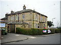
Currock House
One of the buildings that make up Currock Community Centre http://www.currockcommunitycentre.org.uk/ , located in Lediard Avenue. Currock House was built around 1832, and became a Community Centre in 1934. It is a Grade II listed building http://www.imagesofengland.org.uk/details/default.aspx?id=386779 .
Image: © Rose and Trev Clough
Taken: 11 Apr 2013
0.10 miles
6
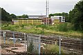
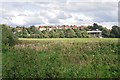
Disused Currock railway yard
This was a wagon repair depot which was closed around 2007, the buildings have since deteriorated.
See photo taken from the opposite direction in 2009 Image .
In the distance, the grey building with a sign on it is DW Fitness on Currock Road.
Information update 31.12.16. The shed has now been demolished.
Image: © Rose and Trev Clough
Taken: 18 Sep 2016
0.11 miles
7
Old railway footbridge, shortly before demolition
A generally disliked crossing over the Cumbrian Coast railway line. Replaced by a new bridge with much better access and visibility for users - see Image .
Zoomed-in shot. Houses at Lund Crescent in the distance.
The bridge was demolished in September 2016.
Image: © Rose and Trev Clough
Taken: 10 Apr 2016
0.11 miles
8
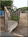
Old Currock footbridge, dismantled
Another section has been loaded onto a trailer (right).
It was taken down almost immediately after the long awaited cycle-friendly replacement was opened Image .
This is how the bridge looked in situ Image .
Image: © Rose and Trev Clough
Taken: 18 Sep 2016
0.11 miles
9
Currock railway footbridge (2) - the steps
Steep steps leading down to Maryport Cottages. This is a quick pedestrian route from Currock to the River Caldew and Denton Holme. But negotiating it is impossible in a wheelchair, and very difficult with a bike or buggy. For other views of the bridge, see Geograph photos http://www.geograph.org.uk/photo/1197295 and http://www.geograph.org.uk/photo/1197293 .
Information update : This bridge was demolished in September 2016, after a much more user-friendly replacement was installed - see Image .
Image: © Rose and Trev Clough
Taken: 21 Feb 2009
0.12 miles
10
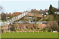
New bridge, nearly finished
The bridge crosses the Cumbrian Coast railway line, connecting the suburbs of Denton Holme and Currock. It is approached by a long but gentle slope, accessible by pedestrians, cyclists and wheelchair users.
On the left, the old metal footbridge is just visible.
This is a zoomed-in view from Holme Head, towards houses on Lund Crescent.
Image: © Rose and Trev Clough
Taken: 26 Aug 2016
0.12 miles