IMAGES TAKEN NEAR TO
Montreal Place, MOOR ROW, CA24 3LJ
Introduction
This page details the photographs taken nearby to Montreal Place, CA24 3LJ by members of the Geograph project.
The Geograph project started in 2005 with the aim of publishing, organising and preserving representative images for every square kilometre of Great Britain, Ireland and the Isle of Man.

There are currently over 7.5m images from over14,400 individuals and you can help contribute to the project by visiting https://www.geograph.org.uk
Image Map
Images are licensed for reuse under creativecommons.org/licenses/by-sa/2.0
Notes
- Clicking on the map will re-center to the selected point.
- The higher the marker number, the further away the image location is from the centre of the postcode.
Image Listing (16 Images Found)
Images are licensed for reuse under creativecommons.org/licenses/by-sa/2.0
Image
Details
Distance
1
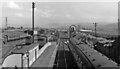
Moor Row station, ex-Whitehaven, Cleator & Egremont Railway 1954
View east, ahead towards Cleator Moor, Ullock and Marron Junction, with lines forking off this, right to Egremont and Sellafield, left to Distington and Siddick on the Cleator & Workington Junction line. See also Image Moor Row had been closed to passengers since 16/6/47, but goods traffic was active on many of the complex of lines in West Cumberland for another 10 years or so; it ceased at Moor Row from 7/3/64, finally ended Whitehaven - Beckermet on 25/9/82.
Image: © Walter Dendy, deceased
Taken: 5 Sep 1954
0.04 miles
2
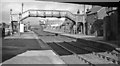
Moor Row station, ex-Whitehaven, Cleator & Egremont Railway 1952
View east on the station, under the B5294 bridge, relatively intact although closed to passengers for five years; for details see Image
Image: © Walter Dendy, deceased
Taken: 13 Jul 1952
0.04 miles
3
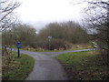
Disused railway junction
The remains of the trackbed of the junction between the Whitehaven, Cleator and Egremont Railway and the Furness and Cleator Railway are used as cycle routes. The Whitehaven, Cleator and Egremont Railway branching to the left is cycle route 71; the Furness and Cleator Railway, to the right, is the C2C, cycle route 72.
Image: © Tim Glover
Taken: 31 Dec 2012
0.04 miles
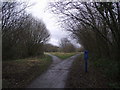
4

A junction on the cycleway at Moor Row
Hadrian's Cycleway and the Coast to Coast use the old railway lines. The blue post marks the Coast to Coast (alternative) route and has an intricate engineering design.
Hadrian's Cycleway runs from Ravenglass to South Shields. See here for more information: https://www.sustrans.org.uk/find-other-routes/hadrians-cycleway
Image: © David Medcalf
Taken: 7 Jul 2022
0.06 miles
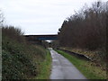
5
Road bridge over C2C Cycleway
Only about 140 miles from the other end of this cycle route across the country.
Image: © John Holmes
Taken: 11 Dec 2005
0.11 miles
6
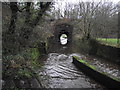
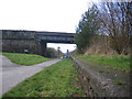
Railway Bridge over the River Keekle
This bridge once carried the Whitehaven, Cleator and Egremont Railway over the River Keekle. This bridge is now used for cycle route 71.
Image: © Tim Glover
Taken: 31 Dec 2012
0.11 miles
7
Disused railway junction
A disused railway junction provides a formation for cycle routes. The Whitehaven, Cleator and Egremont Railway headed off to the left while the formation to the right, now cycle route 71, was a branch to serve iron works in the Cleator Moor area.
Image: © Tim Glover
Taken: 31 Dec 2012
0.11 miles
8
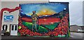
Moor Row mural
The mural is situated on the gable end wall of the Emmanuel Church/ Phoenix youth centre. It was commissioned as part of the Armistice centenary and it is thanks to Moor Rows own residents who funded the project.
Image: © Colin Kinnear
Taken: 18 Mar 2019
0.12 miles
9

The cycle route crosses Blind Lane
This is not the original railway bridge, but I don't know why it has the cage-like design.
Image: © David Medcalf
Taken: 7 Jul 2022
0.14 miles
10
Remains of platform at Moor Row station
Remains of platform at Moor Row station on the Whitehaven, Cleator and Egremont Railway; the trackbed is now part of C2C, cycle route 72.
Image: © Tim Glover
Taken: 31 Dec 2012
0.14 miles