IMAGES TAKEN NEAR TO
Kinniside, CLEATOR, CA23 3AH
Introduction
This page details the photographs taken nearby to CA23 3AH by members of the Geograph project.
The Geograph project started in 2005 with the aim of publishing, organising and preserving representative images for every square kilometre of Great Britain, Ireland and the Isle of Man.

There are currently over 7.5m images from over14,400 individuals and you can help contribute to the project by visiting https://www.geograph.org.uk
Image Map
Images are licensed for reuse under creativecommons.org/licenses/by-sa/2.0
Notes
- Clicking on the map will re-center to the selected point.
- The higher the marker number, the further away the image location is from the centre of the postcode.
Image Listing (8 Images Found)
Images are licensed for reuse under creativecommons.org/licenses/by-sa/2.0
Image
Details
Distance
1
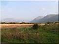
Ennerdale from near Lanefoot
Enticing views to Crag Fell and Angler's Crag from the Coast-to-Coast path on the approach to Ennerdale Bridge, typically at the end of the first day's walking.
Image: © Dave Dunford
Taken: 15 Oct 2006
0.04 miles
3

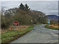
Old Direction Sign - Signpost by Cold Fell Road, Ennerdale and Kinninside parish
Annulus finial - 3 arms, 1 missing; Cumberland named halo by the UC road, in parish of Ennerdale and Kinninside (Copeland District), Cold Fell Road, West of Ennerdale Bridge, on grassy corner. See also https://www.geograph.org.uk/photo/7611002 which shows this after it was refurbished.
To be surveyed
Milestone Society National ID: CU_NY0615
Image: © T Calvin
Taken: 11 Jul 2018
0.16 miles
4

Direction Sign – Signpost beside the Cold Fell Road
Located on the southwest side of Cold Fell Road, west of Ennerdale Bridge. Ennerdale and Kinninside parish. 3 arms and annulus finial. See also https://www.geograph.org.uk/photo/6049949 which shows this before it was refurbished. See also http://www.geograph.org.uk/photo/1387887 and http://www.geog.port.ac.uk/webmap/thelakes/photos/bwj95.jpg.
Milestone Society National ID: CU_NY0615
Image: © B Todd
Taken: 21 Sep 2023
0.16 miles
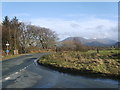
5
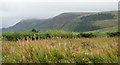
Rose bay willowherb at edge of rough ground
The roughly vegetated ground lies at the road junction south-west of the village of Ennerdale Bridge. The hill near to the centre of the image is Grike, that just rising into mist is Crag Fell.
Image: © Trevor Littlewood
Taken: 7 Sep 2017
0.16 miles
6
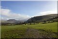
Fields south of Ennerdale Bridge
The conspicuous hill in the centre of the picture is Great Borne, with Starling Dodd beyond.
Image: © David Purchase
Taken: 3 Aug 2012
0.16 miles
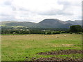
8
Road to Ennerdale Bridge
Herdus on the skyline
Image: © Michael Graham
Taken: 17 Jan 2009
0.18 miles