IMAGES TAKEN NEAR TO
CLEATOR, CA23 3AD
Introduction
This page details the photographs taken nearby to CA23 3AD by members of the Geograph project.
The Geograph project started in 2005 with the aim of publishing, organising and preserving representative images for every square kilometre of Great Britain, Ireland and the Isle of Man.

There are currently over 7.5m images from over14,400 individuals and you can help contribute to the project by visiting https://www.geograph.org.uk
Image Map
Images are licensed for reuse under creativecommons.org/licenses/by-sa/2.0
Notes
- Clicking on the map will re-center to the selected point.
- The higher the marker number, the further away the image location is from the centre of the postcode.
Image Listing (8 Images Found)
Images are licensed for reuse under creativecommons.org/licenses/by-sa/2.0
Image
Details
Distance
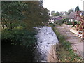
1
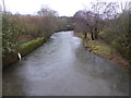
The River Ehen
Looking upstream from the footbridge.
Image: © David Medcalf
Taken: 3 Dec 2015
0.09 miles
2
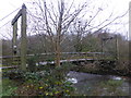
The footbridge over the Ehen
Leading from the car park to Longlands Lake.
Image: © David Medcalf
Taken: 3 Dec 2015
0.12 miles
3
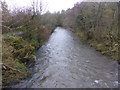
The River Ehen
Looking downstream from the footbridge to Longlands Lake. The river was 'regulated' [made straight] years ago to avoid interfering with the local mine. Eventually it got its own back by flooding the mine.
Image: © David Medcalf
Taken: 3 Dec 2015
0.14 miles
4
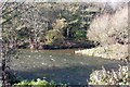
The Keekle meets the Ehen
Looking west at the meeting point of the rivers Ehen and Keekle. The Keekle is coloured a distinct red by the iron oxide picked up on its travels through the disused mines to the north.
Image: © Tom Pullman
Taken: 13 Nov 2005
0.15 miles
5
River Ehen, Cleator
Looking downstream from Blackhow Bridge on the Coast-to-Coast path.
Image: © Dave Dunford
Taken: 15 Oct 2006
0.20 miles
6
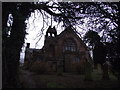
St Leonard's Church
St Leonard's Church, Cleator
Image: © Tim Glover
Taken: 31 Dec 2012
0.24 miles
7
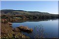
Longlands Lake
Longlands Lake was created (more recently than 1940 going on the old OS map) by the gradual subsidence of the thoroughly undermined ground here - not a bad thing at all really, as it's now a local beauty spot and a haven for waterfowl.
Image: © Tom Pullman
Taken: 13 Nov 2005
0.24 miles
8
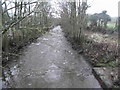
River Keekle
River Keekle looking downstream from Wainwright's Coast to Coast Path in Church Street, Cleator
Image: © Tim Glover
Taken: 31 Dec 2012
0.25 miles