IMAGES TAKEN NEAR TO
Woodend, EGREMONT, CA22 2SZ
Introduction
This page details the photographs taken nearby to CA22 2SZ by members of the Geograph project.
The Geograph project started in 2005 with the aim of publishing, organising and preserving representative images for every square kilometre of Great Britain, Ireland and the Isle of Man.

There are currently over 7.5m images from over14,400 individuals and you can help contribute to the project by visiting https://www.geograph.org.uk
Image Map
Images are licensed for reuse under creativecommons.org/licenses/by-sa/2.0
Notes
- Clicking on the map will re-center to the selected point.
- The higher the marker number, the further away the image location is from the centre of the postcode.
Image Listing (17 Images Found)
Images are licensed for reuse under creativecommons.org/licenses/by-sa/2.0
Image
Details
Distance
1
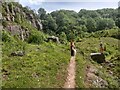
A path in Clints Quarry Nature Reserve
Image: © David Medcalf
Taken: 7 Jun 2019
0.07 miles
2
Clints Quarry NNR
The quarry is a scheduled Site of Special Scientific Interest and is of considerable botanical importance as well as geological. The fallen blocks of stone that may be seen contain a variety of fossils – Brachiopods and corals.
Clints was mentioned in a 1909 prospectus for the Workington Iron & Steel Company. The limestone which was easily quarried, was used in blast furnaces to make steel in the heyday of the Acid Bessemer process between 1850 and 1890. It was transported from the quarry by rail from a siding off the L & N.W. Junction Railway.
Image: © Matthew Hatton
Taken: 19 May 2015
0.08 miles
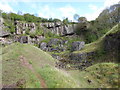
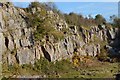
3
Clints Quarry - Limestones
Large limestone quarry exploiting large beds of clean limestone for iron making and lime production. The limestones are Dinantian in age (Early Carboniferous, around 350 million years old) and belong to the Chief Limestone Group.
This whole quarry mined the fourth limestone which is split into a variety of other smaller limestones.
At the time of formation Britain was around the equator, the limestones formed on a proximal inner carbonate ramp on the shores of the Lake District Island! In the quarry algal mats, corals (rugose), braciopods and other sea creatures are present. Sea level changes often meant the limestones were eroded and caves formed (think Zanzibar for an analogue). Another feature described in this quarry are the bentonite bands (clays) which are the remains of volcanic ash fall outs.
Image: © Ashley Dace
Taken: 27 Oct 2015
0.09 miles
4
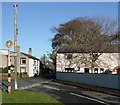
Woodend
Houses in the village of Woodend. The owners of Woodend Barn (on the right) specifically requested that a photo of their house go on this website, and who am I to disappoint them...
Image: © Tom Pullman
Taken: 13 Nov 2005
0.10 miles
5
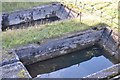
Clints Quarry - Pools
A couple of pools, not sure of their use. A heron was here before it flew off.
Image: © Ashley Dace
Taken: 27 Oct 2015
0.11 miles
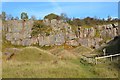
6

Clints Quarry - Limestones
I think (i'm not a carbonate geologist I must stress!) these are the remains of algal mats.
Image: © Ashley Dace
Taken: 27 Oct 2015
0.12 miles
7
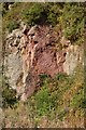
Clints Quarry - Iron Staining
A small fault has a light coating of hematite. The iron ore mines of the area exploited faults like these.
Image: © Ashley Dace
Taken: 27 Oct 2015
0.13 miles
8
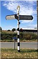
Old Direction Sign - Signpost in Woodend, Egremont parish
Annulus finial - 3 Worboys arms; Cumberland named halo by the UC road, in parish of Egremont (Allerdale District), T-junction at South end of Woodend, on large grass triangle by letterbox and telegraph pole.
To be surveyed
Milestone Society National ID: CU_NY0012
Image: © Milestone Society
Taken: Unknown
0.14 miles
9
Clints Quarry - Limestones
Large limestone quarry exploiting large beds of clean limestone for iron making and lime production. The limestones are Dinantian in age (Early Carboniferous, around 350 million years old) and belong to the Chief Limestone Group.
This whole quarry mined the fourth limestone which is split into a variety of other smaller limestones.
At the time of formation Britain was around the equator, the limestones formed on a proximal inner carbonate ramp on the shores of the Lake District Island! In the quarry algal mats, corals (rugose), braciopods and other sea creatures are present. Sea level changes often meant the limestones were eroded and caves formed (think Zanzibar for an analogue). Another feature described in this quarry are the bentonite bands (clays) which are the remains of volcanic ash fall outs.
Image: © Ashley Dace
Taken: 27 Oct 2015
0.14 miles
10
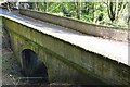
Clints Quarry - Railway Bridge
Access spur to export the limestone to customers.
Image: © Ashley Dace
Taken: 27 Oct 2015
0.16 miles