IMAGES TAKEN NEAR TO
EGREMONT, CA22 2QN
Introduction
This page details the photographs taken nearby to CA22 2QN by members of the Geograph project.
The Geograph project started in 2005 with the aim of publishing, organising and preserving representative images for every square kilometre of Great Britain, Ireland and the Isle of Man.

There are currently over 7.5m images from over14,400 individuals and you can help contribute to the project by visiting https://www.geograph.org.uk
Image Map
Images are licensed for reuse under creativecommons.org/licenses/by-sa/2.0
Notes
- Clicking on the map will re-center to the selected point.
- The higher the marker number, the further away the image location is from the centre of the postcode.
Image Listing (4 Images Found)
Images are licensed for reuse under creativecommons.org/licenses/by-sa/2.0
Image
Details
Distance
1
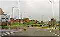
Egremont: site of former station, 1994
View NE at the roundabout on the A595 Barrow- Whitehaven road. The station had been just up to the left here: ex-LNW & Furness Joint, Whitehaven, Cleator & Egremont line; Moor Row (to left) - Sellafield (to right). The station (and line) had a complex history, being first closed to passengers 7/1/35, but reopened for workmen 11/3/40, for the public 6/5/46 - 16/6/47, but again for workmen 23/5/49 - 6/9/65, for schools 3/3/69. It and the line remained for goods until 15/6/72. (!)
Image: © Ben Brooksbank
Taken: 4 Jul 1994
0.23 miles
2
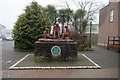
When I Was A Lad
A sculpture by Colin Telfer dedicated to the children of Egremont and sited near the top of Main Street and close to Haematite Man. See NY0110: Memorial to The Redman, submitted by H Stamper.
Image: © David Rogers
Taken: 23 Apr 2008
0.23 miles
4
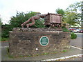
Memorial to The Redmen
Remembers the Iron Ore Miners of the district.
Image: © H Stamper
Taken: 3 Oct 2007
0.25 miles