IMAGES TAKEN NEAR TO
Gillfoot Road, EGREMONT, CA22 2QD
Introduction
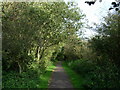
This page details the photographs taken nearby to Gillfoot Road, CA22 2QD by members of the Geograph project.
The Geograph project started in 2005 with the aim of publishing, organising and preserving representative images for every square kilometre of Great Britain, Ireland and the Isle of Man.

There are currently over 7.5m images from over14,400 individuals and you can help contribute to the project by visiting https://www.geograph.org.uk
Image Map
Images are licensed for reuse under creativecommons.org/licenses/by-sa/2.0
Notes
- Clicking on the map will re-center to the selected point.
- The higher the marker number, the further away the image location is from the centre of the postcode.
Image Listing (7 Images Found)
Images are licensed for reuse under creativecommons.org/licenses/by-sa/2.0
Image
Details
Distance
1
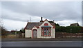
Old Toll House on North Road (A595), Egremont
Dated 1856.
Image: © JThomas
Taken: 16 Nov 2019
0.13 miles
2
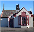
Tollhouse by the A595, North Road, Egremont
Tollhouse by the A595, in the parish of Egremont (Copeland District), Toll Bar Cottage, North Road, Egremont.
Grade II listed.
List Entry Number: 1312427 https://historicengland.org.uk/listing/the-list/list-entry/1312427
To be surveyed
Milestone Society National ID: CB.EGR02
Image: © Milestone Society
Taken: Unknown
0.13 miles
3
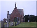
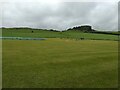
Egremont Cemetery.
There are 2 buildings in the cemetery and 1 church marked on my map. It may well be a chapel for services that is marked.
Image: © John Holmes
Taken: 11 Dec 2005
0.15 miles
5
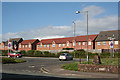
New Houses in Egremont
These new houses overlook the bypass round Egremont.
Image: © Anne Burgess
Taken: 22 May 2013
0.21 miles