1
Farmstead in Haile village
Vernacular farm building and farmhouse
Image: © P Gaskell
Taken: Unknown
0.05 miles
2
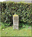
Old Milestone in Haile
Carved stone post by the UC road, in parish of HAILE (COPELAND District), Beck Brow, Haile village, T-junction against wall, on East side of road. Egremont stone, erected by the Egremont to Salthouse turnpike trust in the 19th century.
Inscription reads:-
: To / Ennerdale / Bridge / 2 Miles : : To / Egremont / (?) Miles :
Grade II Listed. List Entry Number: 1336075
https://historicengland.org.uk/listing/the-list/list-entry/1336075
Milestone Society National ID: CU_CBEG.
Image: © CF Smith
Taken: 12 Jul 2010
0.08 miles
3
The village of Haile, West Cumbria
A small village characterised by traditional sandstone buildings such as these.
Image: © Nigel Monckton
Taken: 2 Sep 2005
0.09 miles
4
Old Milestone by Hardgates Road, south of Haile
Carved stone post by the UC road, in parish of HAILE (COPELAND District), Hardgates Road, by "Langdale", on grass verge at T-junction, on West side of road. Egremont stone, erected by the Egremont to Salthouse turnpike trust in the 19th century.
Inscription reads:-
: To / Calder / Bridge / 2 Miles : : TO / Becker / mont / ½ Mile :
Carved benchmark on lower right face.
Grade II Listed. List Entry Number: 1063738
https://historicengland.org.uk/listing/the-list/list-entry/1063738
Milestone Society National ID: CU_CBBM02.
Image: © CF Smith
Taken: 12 Jul 2010
0.10 miles
5
Old Milestone by Hardgates Road, south of Haile
Carved stone post by the UC road, in parish of HAILE (COPELAND District), Hardgates Road, by "Langdale", on grass verge at T-junction, on West side of road. Egremont stone, erected by the Egremont to Salthouse turnpike trust in the 19th century.
Inscription reads:-
: To / Calder / Bridge / 2 Miles : : TO / Becker / mont / ½ Mile :
Carved benchmark on lower right face.
Grade II Listed. List Entry Number: 1063738 https://historicengland.org.uk/listing/the-list/list-entry/1063738
Milestone Society National ID: CU_CBBM02.
Image: © Barbara Todd
Taken: 18 Aug 2023
0.10 miles
6
Milestone - Calder Bridge 2
The OS cut mark on the stone marks a point 82.320m above mean sea level.
Image: © Adrian Dust
Taken: 7 Nov 2016
0.10 miles
7
Ordnance Survey Cut Mark
This OS cut mark can be found on the roadside building at Town End Farm. It marks a point 78.367m above mean sea level.
Image: © Adrian Dust
Taken: 7 Nov 2016
0.24 miles


