IMAGES TAKEN NEAR TO
Calderbridge, SEASCALE, CA20 1DW
Introduction
This page details the photographs taken nearby to CA20 1DW by members of the Geograph project.
The Geograph project started in 2005 with the aim of publishing, organising and preserving representative images for every square kilometre of Great Britain, Ireland and the Isle of Man.

There are currently over 7.5m images from over14,400 individuals and you can help contribute to the project by visiting https://www.geograph.org.uk
Image Map
Images are licensed for reuse under creativecommons.org/licenses/by-sa/2.0
Notes
- Clicking on the map will re-center to the selected point.
- The higher the marker number, the further away the image location is from the centre of the postcode.
Image Listing (3 Images Found)
Images are licensed for reuse under creativecommons.org/licenses/by-sa/2.0
Image
Details
Distance
1
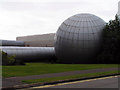
Sellafield Visitors Centre
The Sellafield Visitors Centre is a popular tourist attraction on the west coast of Cumbria.
Image: © Nigel Monckton
Taken: 30 Aug 2005
0.07 miles
3
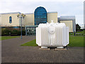
Sellafield Visitor Centre
Sellafield Visitor Centre was built adjacent to the nuclear power station, reprocessing site and all of the other facilities on the vast plant just north of Seascale. The facility was open to the public at the time the image was recorded (January 2005) but it seems now to be closed. The white structure standing in front of the main building is a nuclear fuel flask, used to transport spent fuel to Sellafield. (Thanks to Ian Taylor for identifying the vessel.)
Image: © Trevor Littlewood
Taken: 25 Jan 2005
0.24 miles