IMAGES TAKEN NEAR TO
Irton, HOLMROOK, CA19 1TD
Introduction
This page details the photographs taken nearby to CA19 1TD by members of the Geograph project.
The Geograph project started in 2005 with the aim of publishing, organising and preserving representative images for every square kilometre of Great Britain, Ireland and the Isle of Man.

There are currently over 7.5m images from over14,400 individuals and you can help contribute to the project by visiting https://www.geograph.org.uk
Image Map
Images are licensed for reuse under creativecommons.org/licenses/by-sa/2.0
Notes
- Clicking on the map will re-center to the selected point.
- The higher the marker number, the further away the image location is from the centre of the postcode.
Image Listing (5 Images Found)
Images are licensed for reuse under creativecommons.org/licenses/by-sa/2.0
Image
Details
Distance
2
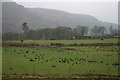
The Wrong Farm!
Leaving the road; the sheep had obviously not read the sign, indicating that Plumgarth is a dairy farm. In the Eskdale Valley, close to Eskdale Green.
Image: © Peter Trimming
Taken: 16 Jun 2013
0.20 miles
3
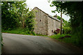
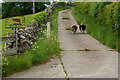
Slapestones, Eskdale Green, Cumbria
The farmhouse lies just beyond the barn.
Image: © Peter Trimming
Taken: 16 Jun 2013
0.20 miles
4
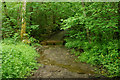
Bridleway at Irton Park, Cumbria
The southern end of the bridleway, seen from the road. The ford is marked on the map; luckily, after a period of dry weather, it did not pose a problem.
Image: © Peter Trimming
Taken: 16 Jun 2013
0.23 miles
5
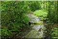
Bridleway at Irton Park, Cumbria
The southern end of the bridleway, with the road just visible. The ford is marked on the map; luckily, after a period of dry weather, it did not pose a problem.
Image: © Peter Trimming
Taken: 16 Jun 2013
0.23 miles