IMAGES TAKEN NEAR TO
Newbiggin-on-Lune, KIRKBY STEPHEN, CA17 4NT
Introduction
This page details the photographs taken nearby to CA17 4NT by members of the Geograph project.
The Geograph project started in 2005 with the aim of publishing, organising and preserving representative images for every square kilometre of Great Britain, Ireland and the Isle of Man.

There are currently over 7.5m images from over14,400 individuals and you can help contribute to the project by visiting https://www.geograph.org.uk
Image Map
Images are licensed for reuse under creativecommons.org/licenses/by-sa/2.0
Notes
- Clicking on the map will re-center to the selected point.
- The higher the marker number, the further away the image location is from the centre of the postcode.
Image Listing (46 Images Found)
Images are licensed for reuse under creativecommons.org/licenses/by-sa/2.0
Image
Details
Distance
1
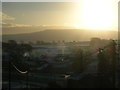
Winter morning, Newbiggin-on-Lune
Wild Boar Fell on the horizon.
Image: © John H Darch
Taken: 5 Jan 2009
0.02 miles
2
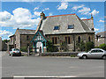
Former church in Newbiggin
This building looks like it may have been a church or a school, although the stone crosses on the roof suggest the former. Confirmed by checking on 19thC OS maps. Now converted to a dwelling.
Image: © Gordon Hatton
Taken: 16 May 2019
0.03 miles
3
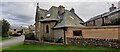
'Aidans', formerly St Aidan's Church
There is an Ordnance Survey benchmark Image on the far corner of the house
Image: © Roger Templeman
Taken: 15 Sep 2022
0.04 miles
4
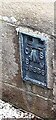
Benchmark on Aidans, formerly St Aidan's Church
Ordnance Survey flush bracket (serial identifier S6859) benchmark levelled in 1969 at 240.545m above Newlyn Datum and verified in 1970
Image: © Roger Templeman
Taken: 15 Sep 2022
0.04 miles
5

'Aidans' a private residence, previously St Aidan's Church, on NE side Main Street
Image: © Luke Shaw
Taken: 15 Sep 2022
0.04 miles
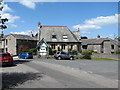
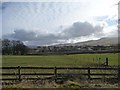
6

The village of Newbiggin-on-Lune
Newbiggin is generally regarded as being the source of the River Lune, as several small becks converge near here, and none is distinctive enough to be regarded as 'the' source. Land 500 metres east, however, drains into the River Eden.
Image: © David Purchase
Taken: 14 Jul 2013
0.04 miles
7
Converted chapel, Newbiggin-on-Lune
On the corner of Main Street (left) and Chapel Butt Lane (right).
Image: © Stephen Craven
Taken: 23 Jun 2009
0.04 miles
8
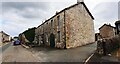
Corn Mill and Low House on SW side of Main Street
There is an Ordnance Survey benchmark on the near corner of the mill building below its black downpipe
Image: © Roger Templeman
Taken: 15 Sep 2022
0.04 miles
9
Newbiggin on Lune
Looking southwards from the former railway line.
Image: © Christine Johnstone
Taken: 4 Mar 2014
0.04 miles
10
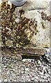
Benchmark on Corn Mill building, on SW side of Main Street
Ordnance Survey cut mark benchmark levelled at 237.220m above Newlyn Datum in 1969 and verified in 1970
Image: © Roger Templeman
Taken: 15 Sep 2022
0.05 miles