IMAGES TAKEN NEAR TO
Ravenstonedale, KIRKBY STEPHEN, CA17 4LJ
Introduction
This page details the photographs taken nearby to CA17 4LJ by members of the Geograph project.
The Geograph project started in 2005 with the aim of publishing, organising and preserving representative images for every square kilometre of Great Britain, Ireland and the Isle of Man.

There are currently over 7.5m images from over14,400 individuals and you can help contribute to the project by visiting https://www.geograph.org.uk
Image Map
Images are licensed for reuse under creativecommons.org/licenses/by-sa/2.0
Notes
- Clicking on the map will re-center to the selected point.
- The higher the marker number, the further away the image location is from the centre of the postcode.
Image Listing (31 Images Found)
Images are licensed for reuse under creativecommons.org/licenses/by-sa/2.0
Image
Details
Distance
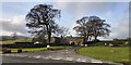
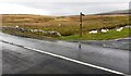
2
En route to Appleby
These are all travelling to the Appleby Horse Fair which takes place the following week. Many of the lay bys and fell open spaces show similar scenes.
Image: © William Metcalfe
Taken: 4 Jun 2007
0.03 miles
3
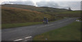
Motorbike on the A683 at Crooks Beck
Heading south at speed below Wild Boar Fell towards Sedbergh.
Image: © Karl and Ali
Taken: 11 Nov 2012
0.04 miles
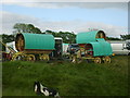
4
Horse traders
Scenes like this are a common sight in the week leading to the Appleby Horse Fair.
Image: © William Metcalfe
Taken: 4 Jun 2007
0.04 miles
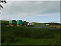
5
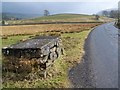
Milk churn stand near Crooks Bank
Before bulk tankers came to farms to collect the milk it was taken to the road side in churns. The churns were placed on this type of stand to make loading them on to lorries easier.
Image: © Maigheach-gheal
Taken: 24 Mar 2010
0.05 miles
6
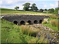
Crooks Beck South Bridge
An interesting road bridge on the A683 near Kirkby Stephen.
Image: © John Illingworth
Taken: 12 Sep 2007
0.08 miles
7
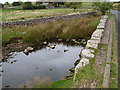
SE parapet of Crooks Beck South Bridge taking Egdale Lane over stream
There is an Ordnance Survey benchmark Image on top of the parapet over the near bank of the stream
Image: © Roger Templeman
Taken: 14 Oct 2022
0.09 miles
8
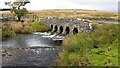
Crooks Beck South Bridge taking A683 (Egdale Lane) over stream
Image: © Roger Templeman
Taken: 14 Oct 2022
0.09 miles
9

Benchmark on top of SE parapet of Crooks Beck South Bridge
Ordnance Survey rivet benchmark levelled at 271.467m above Newlyn Datum verified 1953
Image: © Roger Templeman
Taken: 14 Oct 2022
0.09 miles
10
Crooks Beck
Crooks Beck as it flows out from under the A683.
Image: © David McMumm
Taken: 2 Oct 2009
0.09 miles