IMAGES TAKEN NEAR TO
Hartley, KIRKBY STEPHEN, CA17 4JJ
Introduction
This page details the photographs taken nearby to CA17 4JJ by members of the Geograph project.
The Geograph project started in 2005 with the aim of publishing, organising and preserving representative images for every square kilometre of Great Britain, Ireland and the Isle of Man.

There are currently over 7.5m images from over14,400 individuals and you can help contribute to the project by visiting https://www.geograph.org.uk
Image Map
Images are licensed for reuse under creativecommons.org/licenses/by-sa/2.0
Notes
- Clicking on the map will re-center to the selected point.
- The higher the marker number, the further away the image location is from the centre of the postcode.
Image Listing (50 Images Found)
Images are licensed for reuse under creativecommons.org/licenses/by-sa/2.0
Image
Details
Distance
2
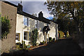
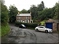
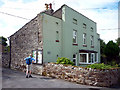
Hartley
Looking up the lane to Hartley Castle.
Image: © Ian Taylor
Taken: 25 Oct 2011
0.02 miles
4
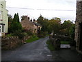
Hartley
Pretty village east of Kirkby Stephen on the Coast-to-Coast long-distance footpath.
Image: © Dave Dunford
Taken: 21 Oct 2006
0.03 miles
5
Hartley
A double bend in the main road at the south end of the village.
Image: © John Allan
Taken: 9 Sep 2018
0.05 miles
6
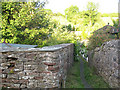
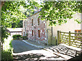
Narrow passage in Hartley village
The village essentially consists of two parallel lanes either side of a stream, and this passageway connects them by means of a footbridge (just visible).
Image: © Stephen Craven
Taken: 25 Jun 2009
0.05 miles
7
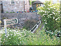
Footpath in Hartley village
The other end of the passageway shown in Image - the footbridge is shown in both photos.
Image: © Stephen Craven
Taken: 25 Jun 2009
0.05 miles
8
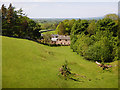
Looking northwest from Merrygill Viaduct
Looking down over pasture to the outlying farms of Hartley, from the parapet of Merrygill viaduct (now owned by the Northern Viaduct Trust). Hartley Beck is the stream crossed and this flows among the trees to the right of the photo, on its way down to the River Eden through rich farmland. Having been bothered by the RAF earlier in the day, persistently flying noisy circles over the Warcop training area, we were treated to a much smaller flying display here, as a young man was piloting a small drone taking aerial footage over the viaduct. His approach to safety was admirable, with lots of warning signs so that we weren't surprised by the remotely operated aircraft.
Image: © Andy Waddington
Taken: 22 May 2018
0.07 miles
10
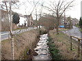
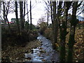
Hartley Beck at Hartley
The stream runs through the centre of this small, charming village.
Image: © David Medcalf
Taken: 21 Jan 2006
0.10 miles