IMAGES TAKEN NEAR TO
Vicarage Drive, KIRKBY STEPHEN, CA17 4EH
Introduction
This page details the photographs taken nearby to Vicarage Drive, CA17 4EH by members of the Geograph project.
The Geograph project started in 2005 with the aim of publishing, organising and preserving representative images for every square kilometre of Great Britain, Ireland and the Isle of Man.

There are currently over 7.5m images from over14,400 individuals and you can help contribute to the project by visiting https://www.geograph.org.uk
Image Map
Images are licensed for reuse under creativecommons.org/licenses/by-sa/2.0
Notes
- Clicking on the map will re-center to the selected point.
- The higher the marker number, the further away the image location is from the centre of the postcode.
Image Listing (157 Images Found)
Images are licensed for reuse under creativecommons.org/licenses/by-sa/2.0
Image
Details
Distance
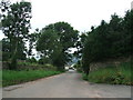
2
Across the fields
Taken from Church entrance looking away from Church across the fields
Image: © colin
Taken: 29 Nov 2021
0.05 miles
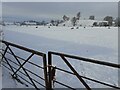
3
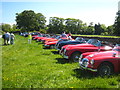
Field in Church Brough
This field right in the centre of the village served as a temporary car park for a classic car rally stopping off at the castle.
Image: © Rod Allday
Taken: 2 Jun 2011
0.06 miles
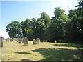
4
![Parish church [7]](https://s2.geograph.org.uk/geophotos/07/30/23/7302322_86ff3024_120x120.jpg)
Parish church [7]
Part of the churchyard.
The Anglican parish church of St Michael has parts from the 12th, 14th and 16th centuries. Constructed of coursed, squared sandstone under lead roofs. Being close to the castle, some 200 yards distant, the church was often targeted by raiding parties from the Scottish borders. Listed, grade II*, with details at: https://historicengland.org.uk/listing/the-list/list-entry/1144902
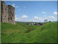
Brough is a village in the Eden district of Cumbria, some 21 miles northeast of Kendal and about 30 miles west of Darlington. The village is on the A66 road, a key route across the Pennine Mountains via the Stainmore Pass. Brough is on the site of the Roman fort of Verterae and has the ruins of a Norman castle. The village has historically been divided into Market Brough, to the north, and Church Brough, to the south.
Image: © Michael Dibb
Taken: 20 Jun 2022
0.08 miles
5
The south side of the churchyard
Church Brough.
Image: © Jonathan Thacker
Taken: 19 Jul 2013
0.08 miles
6
View over Church Brough
From the castle moat.
Image: © Jonathan Thacker
Taken: 19 Jul 2013
0.08 miles
7
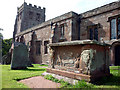
Tomb of the Waltons of Hilbeck, St Michael's Church, Brough
Hilbeck is now called Hellbeck.
Image: © Karl and Ali
Taken: 26 Aug 2010
0.08 miles
8
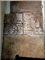
Roman inscribed stones, St Michael's Church, Brough
Built into the west wall of the porch these stones originate from the nearby fort of Verteris http://www.roman-britain.org/places/verteris.htm
Image: © Karl and Ali
Taken: 26 Aug 2010
0.08 miles
9
Hermes of Commagene tablets, bell tower, St Michael's, Brough
These tablets (copies of the original in the FitzWilliam Museum, Cambridge) are dedicated to 16-year-old Hermes of Commagene. Commagene was a small client kingdom of the Romans based in parts of eastern Turkey and Syria. Hermes may have been here in connection with the medical profession attached to the Roman army garrison of Verteris.
Image: © Karl and Ali
Taken: 26 Aug 2010
0.08 miles
10
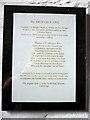
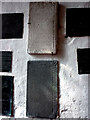
Hermes of Commagene, explanatory notice
Translation of the Brough Stone http://www.geograph.org.uk/photo/2036206 The best-known site in Commagene http://www.adiyamanli.org/mt_nemrut.htm Nemrut Dag in modern Turkey.
Image: © Karl and Ali
Taken: 26 Aug 2010
0.08 miles