IMAGES TAKEN NEAR TO
Brough, KIRKBY STEPHEN, CA17 4AT
Introduction
This page details the photographs taken nearby to CA17 4AT by members of the Geograph project.
The Geograph project started in 2005 with the aim of publishing, organising and preserving representative images for every square kilometre of Great Britain, Ireland and the Isle of Man.

There are currently over 7.5m images from over14,400 individuals and you can help contribute to the project by visiting https://www.geograph.org.uk
Image Map
Images are licensed for reuse under creativecommons.org/licenses/by-sa/2.0
Notes
- Clicking on the map will re-center to the selected point.
- The higher the marker number, the further away the image location is from the centre of the postcode.
Image Listing (148 Images Found)
Images are licensed for reuse under creativecommons.org/licenses/by-sa/2.0
Image
Details
Distance
1
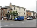
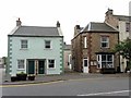
Shop, Main Street, Brough
Village Stores and Off License in the Main Street. The former Post Office shut in 2008 and now Bed & Breakfast accommodation is on the right. There is a photo from 2002 here Image
Image: © Andrew Curtis
Taken: 20 Jul 2015
0.00 miles
2
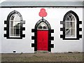
Oddfellows Hall, Brough
The hall is dated 1878 and is a Grade II Listed Building (List Reference 73308). The Oddfellows are one of the earliest and oldest Friendly Societies, the name said to have arisen form there being too few Guild 'Fellows' in the same trade to form a local Guild. The Fellows from a number of trades therefore joined together to form a local Guild of Fellows from an assortment of different trades, the 'Odd Fellows'. The group was originally modelled on Freemasonry and developed its own rites, ceremonies, robes and regalia but provided working men with mutual support and health insurance.
https://en.wikipedia.org/wiki/Oddfellows
The Oddfellows Ball held at Brough in 1888 was deliberately not held in licensed premises and included a tea-party. However, temperance wasn't always their strict policy which led to an alternative movement in this area of Cumbria, the Rechabites.
Image: © Andrew Curtis
Taken: 20 Jul 2015
0.01 miles
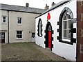
4
![Brough buildings [1]](https://s0.geograph.org.uk/geophotos/07/30/33/7303312_46e3b227_120x120.jpg)
Brough buildings [1]
Now a dwelling, Oddfellows Hall, off Main Street, is dated 1878. Built in stuccoed stone with incised lines to give the appearance of ashlar under a graduated slate roof. Single storey (now divided into 2 storeys internally). Listed, grade II, with details at: https://historicengland.org.uk/listing/the-list/list-entry/1137158
Brough is a village in the Eden district of Cumbria, some 21 miles northeast of Kendal and about 30 miles west of Darlington. The village is on the A66 road, a key route across the Pennine Mountains via the Stainmore Pass. Brough is on the site of the Roman fort of Verterae and has the ruins of a Norman castle. The village has historically been divided into Market Brough, to the north, and Church Brough, to the south.
Image: © Michael Dibb
Taken: 20 Jun 2022
0.01 miles
6
![Brough buildings [3]](https://s0.geograph.org.uk/geophotos/07/30/33/7303320_ad545208_120x120.jpg)
Brough buildings [3]
This seemingly unoccupied and unnamed building between the shop Image and Swanson House Image was built in the late 18th century and restored circa 1985. Possibly a former inn. Constructed of pebbledashed rubble stone under a slate roof. Listed, for group vale, grade II, with details at: https://historicengland.org.uk/listing/the-list/list-entry/1137151
Brough is a village in the Eden district of Cumbria, some 21 miles northeast of Kendal and about 30 miles west of Darlington. The village is on the A66 road, a key route across the Pennine Mountains via the Stainmore Pass. Brough is on the site of the Roman fort of Verterae and has the ruins of a Norman castle. The village has historically been divided into Market Brough, to the north, and Church Brough, to the south.
Image: © Michael Dibb
Taken: 20 Jun 2022
0.01 miles
7
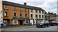
![Brough buildings [2]](https://s3.geograph.org.uk/geophotos/07/30/33/7303315_6975333b_120x120.jpg)
Brough buildings [2]
This shop with living accommodation above is dated 1699 and has been altered later. Constructed of rendered rubble stone under a graduated slate roof. The shopfront is 20th century. Listed, grade II, with details at: https://historicengland.org.uk/listing/the-list/list-entry/1144911
Brough is a village in the Eden district of Cumbria, some 21 miles northeast of Kendal and about 30 miles west of Darlington. The village is on the A66 road, a key route across the Pennine Mountains via the Stainmore Pass. Brough is on the site of the Roman fort of Verterae and has the ruins of a Norman castle. The village has historically been divided into Market Brough, to the north, and Church Brough, to the south.
Image: © Michael Dibb
Taken: 20 Jun 2022
0.01 miles
9
Main Street, Brough
Cottage on the corner of New Road. The narrow lane leads down to Image
Image: © Andrew Curtis
Taken: 20 Jul 2015
0.02 miles
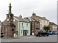
10
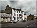
Castle Hotel, Market Street, Brough
Looking along Market Street, Brough.
Image: © David Dixon
Taken: 24 Jun 2011
0.02 miles