IMAGES TAKEN NEAR TO
Great Asby, APPLEBY-IN-WESTMORLAND, CA16 6TH
Introduction
This page details the photographs taken nearby to CA16 6TH by members of the Geograph project.
The Geograph project started in 2005 with the aim of publishing, organising and preserving representative images for every square kilometre of Great Britain, Ireland and the Isle of Man.

There are currently over 7.5m images from over14,400 individuals and you can help contribute to the project by visiting https://www.geograph.org.uk
Image Map
Images are licensed for reuse under creativecommons.org/licenses/by-sa/2.0
Notes
- Clicking on the map will re-center to the selected point.
- The higher the marker number, the further away the image location is from the centre of the postcode.
Image Listing (3 Images Found)
Images are licensed for reuse under creativecommons.org/licenses/by-sa/2.0
Image
Details
Distance
1
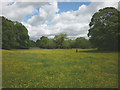
Meadow beside Scale Beck
The footpath down to Rutter Force passes through extensive meadows lined with mature trees. Today they were ablaze with buttercups. Beyond the trees, the tip of Murton Pike can just be seen.
Image: © Karl and Ali
Taken: 21 Jun 2015
0.05 miles
2
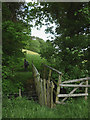
Footbridge over Scale Beck
The footpath down to Rutter Force crosses the beck just below its confluence with Dry Beck.
Image: © Karl and Ali
Taken: 21 Jun 2015
0.11 miles
3
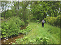
Footpath beside Scale Beck
Just north of Howe Slacks the path runs close by Scale Beck (shortly to join with Dry and Asby Becks to form Hoff Beck). The whole section down to Rutter Force (and beyond) is delightfully pastoral (assuming you don't mind cow pats).
Image: © Karl and Ali
Taken: 21 Jun 2015
0.21 miles