IMAGES TAKEN NEAR TO
Warcop, APPLEBY-IN-WESTMORLAND, CA16 6PE
Introduction
This page details the photographs taken nearby to CA16 6PE by members of the Geograph project.
The Geograph project started in 2005 with the aim of publishing, organising and preserving representative images for every square kilometre of Great Britain, Ireland and the Isle of Man.

There are currently over 7.5m images from over14,400 individuals and you can help contribute to the project by visiting https://www.geograph.org.uk
Image Map
Images are licensed for reuse under creativecommons.org/licenses/by-sa/2.0
Notes
- Clicking on the map will re-center to the selected point.
- The higher the marker number, the further away the image location is from the centre of the postcode.
Image Listing (11 Images Found)
Images are licensed for reuse under creativecommons.org/licenses/by-sa/2.0
Image
Details
Distance
1
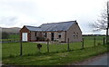
Upper Field View
Bungalow on the B6259 near Warcop.
Image: © JThomas
Taken: 29 Apr 2021
0.00 miles
2
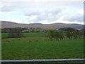
Grazing off the B6259 near Warcop
Looking towards the Eden Valley Railway and Warcop Fell beyond.
Image: © JThomas
Taken: 29 Apr 2021
0.03 miles
3
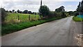
B6259 heading for Warcop as it passes entrance to Upper Field View
Ordnance Survey documents indicate that a benchmark levelled at 146.066m above Newlyn Datum was verified in 1955 on a gatepost at the left hand side of the road
Image: © Roger Templeman
Taken: 6 Aug 2024
0.03 miles
5
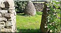
Stone sculpture in stone wall compound
Image: © Roger Templeman
Taken: 6 Aug 2024
0.12 miles
6
Pinfold Cone
A sculpture by Andrew Goldsworthy.
Image: © Mick Garratt
Taken: 3 Nov 2018
0.12 miles
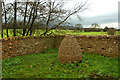
7

Warcop Pinfold with Sculpture in Centre
Image: © Martin Dawes
Taken: 24 Feb 2012
0.13 miles
8

Pinfold and Goldsworthy Sculpture
The Goldsworthy Cone is one of six in the area - all in Pinfolds
Image: © mauldy
Taken: 20 Feb 2009
0.15 miles

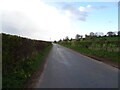
10

Public bridleway to Warcop
Running west from the railway line [and originally the A66].
Image: © Christine Johnstone
Taken: 12 Jun 2016
0.22 miles