IMAGES TAKEN NEAR TO
Sandford, APPLEBY-IN-WESTMORLAND, CA16 6NR
Introduction
This page details the photographs taken nearby to CA16 6NR by members of the Geograph project.
The Geograph project started in 2005 with the aim of publishing, organising and preserving representative images for every square kilometre of Great Britain, Ireland and the Isle of Man.

There are currently over 7.5m images from over14,400 individuals and you can help contribute to the project by visiting https://www.geograph.org.uk
Image Map
Images are licensed for reuse under creativecommons.org/licenses/by-sa/2.0
Notes
- Clicking on the map will re-center to the selected point.
- The higher the marker number, the further away the image location is from the centre of the postcode.
Image Listing (20 Images Found)
Images are licensed for reuse under creativecommons.org/licenses/by-sa/2.0
Image
Details
Distance
5
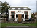
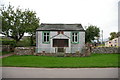
Chapel Cottage, Sandford
Former Wesleyan Association Chapel built in 1849. There is a photo from 2005, before conversion, here Image
Image: © Andrew Curtis
Taken: 22 Oct 2010
0.05 miles

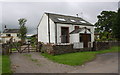
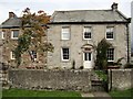
8
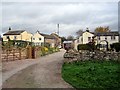
The Square, Sandford
The house on the right was formerly the Black Bull Inn.
Image: © Andrew Curtis
Taken: 22 Oct 2010
0.07 miles
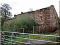
10
Sandford Arms
The entrance to the inn is from the courtyard on the north side Image
Image: © Andrew Curtis
Taken: 22 Oct 2010
0.12 miles