IMAGES TAKEN NEAR TO
Murton, APPLEBY-IN-WESTMORLAND, CA16 6NF
Introduction
This page details the photographs taken nearby to CA16 6NF by members of the Geograph project.
The Geograph project started in 2005 with the aim of publishing, organising and preserving representative images for every square kilometre of Great Britain, Ireland and the Isle of Man.

There are currently over 7.5m images from over14,400 individuals and you can help contribute to the project by visiting https://www.geograph.org.uk
Image Map
Images are licensed for reuse under creativecommons.org/licenses/by-sa/2.0
Notes
- Clicking on the map will re-center to the selected point.
- The higher the marker number, the further away the image location is from the centre of the postcode.
Image Listing (15 Images Found)
Images are licensed for reuse under creativecommons.org/licenses/by-sa/2.0
Image
Details
Distance
1
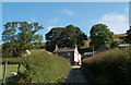
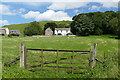
Keisley
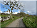
Keisley is a farm lying north of a minor road connecting the villages of Dufton and Murton.
Image: © Trevor Littlewood
Taken: 24 Jul 2011
0.02 miles
3
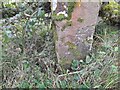
Ordnance Survey Cut Mark
This OS cut mark can be found on the gatepost south side of the road. It marks a point 244.377m above mean sea level.
Image: © Adrian Dust
Taken: 25 Oct 2023
0.16 miles
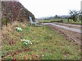
4
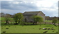
Tidybank Cottage
To the north of the Dufton - Murton road.
Image: © Stephen McKay
Taken: 8 Oct 2006
0.18 miles
6
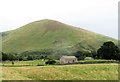
View to Murton Pike from Keisley
Murton Pike is one of a series of 'pikes' that outcrop along the base of the North Pennine Scarp. In shape they are most 'un Pennine' like, which is not surprising as their geology owes more to the Lake District volcanics than to the carboniferous sedimentary rocks of the Pennines.
Image: © Gordon Hatton
Taken: 16 Aug 2018
0.19 miles
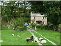
10
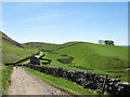
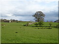
Two hills along line of farm road
The farther hill is named Keisley Bank, the one to the right is Harthwaite; the view is from just south of the Pennine Way.
Image: © Trevor Littlewood
Taken: 11 Jun 2015
0.21 miles