IMAGES TAKEN NEAR TO
Hunriggs Lane, APPLEBY-IN-WESTMORLAND, CA16 6JQ
Introduction
This page details the photographs taken nearby to Hunriggs Lane, CA16 6JQ by members of the Geograph project.
The Geograph project started in 2005 with the aim of publishing, organising and preserving representative images for every square kilometre of Great Britain, Ireland and the Isle of Man.

There are currently over 7.5m images from over14,400 individuals and you can help contribute to the project by visiting https://www.geograph.org.uk
Image Map
Images are licensed for reuse under creativecommons.org/licenses/by-sa/2.0
Notes
- Clicking on the map will re-center to the selected point.
- The higher the marker number, the further away the image location is from the centre of the postcode.
Image Listing (14 Images Found)
Images are licensed for reuse under creativecommons.org/licenses/by-sa/2.0
Image
Details
Distance
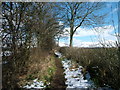
2
Drain west of Moresby Tarn, Hungriggs
Draining the tarn, I think, but it's difficult to tell. The map shows that this tarn is the natural head of the dry valley of Crundale Bottom Image The public footpath goes through the farmyard, but a lack of signs meant the photographer kept to east side of the buildings.
Image: © Christine Johnstone
Taken: 8 Jul 2016
0.05 miles
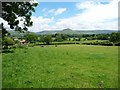
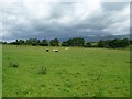
3
![Sheep pasture above [north of] Moresby Tarn](https://s3.geograph.org.uk/geophotos/05/03/19/5031963_26901651_120x120.jpg)
Sheep pasture above [north of] Moresby Tarn
Taken from the public footpath to Flakebridge Wood, part of 'A Pennine Journey'.
Image: © Christine Johnstone
Taken: 8 Jul 2016
0.05 miles
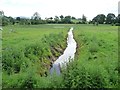
4
Moresby Tarn, east of Hungriggs
The public footpath goes through the farmyard, but a lack of signs meant the photographer kept to east side of the buildings.
Image: © Christine Johnstone
Taken: 8 Jul 2016
0.07 miles
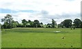
5
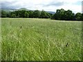
Unmown meadow, north-east of Hungriggs
Surrounded by sheep pasture and woodland.
Image: © Christine Johnstone
Taken: 8 Jul 2016
0.12 miles
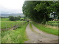
6
Public footpath to Hungriggs
Heading north-east. Part of the route of 'A Pennine Journey', north from Appleby.
Image: © Christine Johnstone
Taken: 8 Jul 2016
0.13 miles
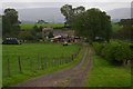
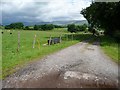
7
Access Track to Hungriggs
Access to Hungriggs, north of the A66 Appleby by-pass.
Image: © Chris Heaton
Taken: 6 Sep 2009
0.16 miles
8
The access track to Hungriggs
Not a public right of way.
Image: © Christine Johnstone
Taken: 8 Jul 2016
0.18 miles
9
Sheep pasture south-west of Hungriggs
The clouds threatened, but it didn't rain.
Image: © Christine Johnstone
Taken: 8 Jul 2016
0.18 miles