IMAGES TAKEN NEAR TO
Dufton, APPLEBY-IN-WESTMORLAND, CA16 6DD
Introduction
This page details the photographs taken nearby to CA16 6DD by members of the Geograph project.
The Geograph project started in 2005 with the aim of publishing, organising and preserving representative images for every square kilometre of Great Britain, Ireland and the Isle of Man.

There are currently over 7.5m images from over14,400 individuals and you can help contribute to the project by visiting https://www.geograph.org.uk
Image Map
Images are licensed for reuse under creativecommons.org/licenses/by-sa/2.0
Notes
- Clicking on the map will re-center to the selected point.
- The higher the marker number, the further away the image location is from the centre of the postcode.
Image Listing (128 Images Found)
Images are licensed for reuse under creativecommons.org/licenses/by-sa/2.0
Image
Details
Distance
1
Pennine Way, north out of Dufton
Dufton is a major stopping point on the Pennine Way. The way north is shown leaving the village towards the major obstacle of Cross Fell, before the descent towards Tynedale.
Image: © Chris Heaton
Taken: 7 Sep 2009
0.01 miles
2
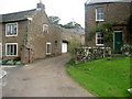
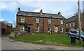
Farm buildings on north side of The Ride
There is an OS benchmark Image near the front right hand corner of the building
Image: © Roger Templeman
Taken: 19 Mar 2019
0.01 miles

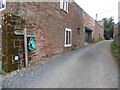
5
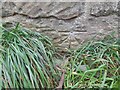
Ordnance Survey 1GL Bolt
This OS bolt can be found on the house NW side of the track. It marks a point 625.5ft above mean sea level.
Image: © Adrian Dust
Taken: 25 Oct 2023
0.01 miles
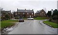
6
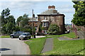
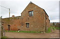
Old Dufton Hall
A grade II listed building
Image: © Graham Hogg
Taken: 25 Aug 2015
0.01 miles
7
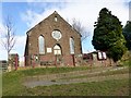
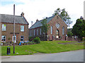
Dufton with Knock Methodist Chapel
It is very likely that the Methodists were active in Dufton in the late 18th Century as there is a record that in 1803 the village had a Wesleyan chapel in the Brough Wesleyan Circuit.
In 1820 a new Wesleyan chapel was built. This building still stands in the village but it ceased to be a chapel and is now a private residence. In 1839 a Primitive Methodist Chapel was opened at a time when Primitive Methodism was spreading quite quickly in the Eden Valley. By about 1900 the members felt that their chapel was too small and inconvenient for their work to be carried out effectively, and they decided to build a chapel nearer the centre of the village and this is the building we now meet together in.
Image: © Rude Health
Taken: 1 Mar 2013
0.02 miles
8
The east end of Dufton
"Many houses in Dufton are made of the local red sandstone, known as the St Bees Sandstone. It dates from the Triassic period, around 250 million years ago, and formed from sand deposited in rivers flowing over desert plains." Quote from the North Pennines AONB Partnership's walks leaflet, 'Geology and landscape around Dufton'.
Image: © Christine Johnstone
Taken: 16 Feb 2017
0.02 miles